Blog
Southeast Texas Weekly Weather Outlook
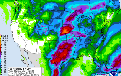
Southeast Texas Weekly Weather Outlook Southeast Texas is heading into another active late-spring weather pattern this week, with warm temperatures, rising humidity, and multiple chances for showers and thunderstorms. While we’re not expecting a complete washout every...
Scattered showers and thunderstorms through the weekend
Fairly complicated forecast over the next few days with an upper level trough moving across the state, a weak surface front lingering offshore into the area, and weak disturbances moving across the region. This all points to chances for showers and thunderstorms at...

Severe Weather and Flood Briefing
Stormy start to the day across Southeast Texas 🌧️ Heavy rain is ongoing mainly north of US-59, and a Flood Watch is in effect today. We’re already seeing street flooding and rising water levels on creeks and bayous, especially north and northwest of the Houston area....

Weekly Outlook 4-26-26
Quiet start to the day across Southeast Texas, but we’re keeping an eye on storms moving through North Texas that could try to hold together as they approach our northern areas later this morning. Most guidance shows them weakening—but we can’t rule out a stronger...

Strong cold front will bring showers and thunderstorms to the area this weekend
Strong cold front will bring showers and thunderstorms to the area this weekend Some rain chances will continue into next week Late season cold front will move across the area Saturday afternoon and evening with showers and thunderstorms. While showers will develop...

Easter Forecast and Outlook
Weekend: Stronger front heads into the area late Saturday and expect a line of showers and thunderstorms to develop and cross the area Saturday afternoon and evening. Widespread moderate to at times heavy rainfall will be possible with this activity given the moisture...

Strong cold front will sweep across the area Sunday evening
A few strong to severe thunderstorms will be possible along the front Strong northerly winds of 35-45mph will occur behind the front Sunday night into early Monday Frost possible Tuesday morning Tranquil weather today and much of Sunday will quickly change as...

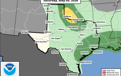
A low end severe weather and excessive rainfall threat will evolve late Saturday into Sunday
Slow moving front will stall over the region this weekend \ There has been little change to the forecast thinking over the last 24 hours as a slow moving frontal boundary moves into the state and eventually stalls over SE TX Saturday afternoon into Sunday before...
A storm system will move across Texas on Saturday
Widespread showers and thunderstorms are likely A few of the storms could become strong or severe in the late afternoon/evening An upper level trough a weak front will move across Texas on Saturday. Ahead of this feature an influx of Gulf moisture will surge into the...