Southeast Texas Weekly Weather Outlook
Southeast Texas is heading into another active late-spring weather pattern this week, with warm temperatures, rising humidity, and multiple chances for showers and thunderstorms. While we’re not expecting a complete washout every day, several rounds of rain and storms could impact the region from early next week through midweek.
After a relatively quiet and warm weekend, moisture levels will increase quickly as Gulf humidity surges back inland. Temperatures will remain above average, with afternoon highs generally in the mid to upper 80s and overnight lows staying muggy in the 70s.
Monday: Humidity Returns, Storm Chances Increase
The pattern begins shifting Monday as a disturbance approaches from the west and deeper tropical moisture moves into Southeast Texas. Scattered showers and thunderstorms are expected to develop during the afternoon and evening hours.
Not everyone will see rain, but storms that do form could produce:
- Heavy downpours
- Frequent lightning
- Gusty winds
- Localized street flooding
Rain coverage should become more widespread Monday night into Tuesday.
Tuesday & Wednesday: Most Active Weather Period
Tuesday and Wednesday currently appear to be the most active days of the week. Forecast guidance suggests an upper-level trough and stalled boundary near the region could help generate multiple rounds of showers and thunderstorms.
At this time, the primary concerns include:
- Heavy rainfall
- Localized flooding
- Strong thunderstorms
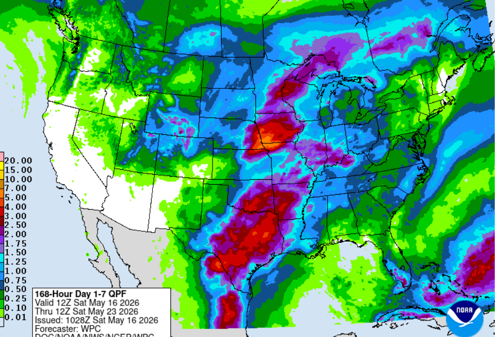
Rainfall totals will vary considerably depending on where storms repeatedly develop, but some areas could pick up 1 to 44 inches of rain with isolated higher totals possible by midweek.
Late Week Outlook
By Thursday and Friday, rain chances may gradually decrease as the disturbance lifts northeast and the atmosphere becomes somewhat less favorable for widespread storms. However, isolated afternoon thunderstorms will likely remain in the forecast as we stay locked into a humid Gulf pattern.
Temperatures should continue running warm with highs near 90 degrees where sunshine breaks through.
What We’re Watching
There are still uncertainties regarding:
- Exact timing of storm clusters
- Placement of the heaviest rainfall axis
- How strong storms become during peak heating
- Whether boundaries stall close enough to enhance flooding concerns
This is a fairly typical late-May Southeast Texas setup where localized impacts can vary dramatically from one community to the next.
Bottom Line
- Warm and humid conditions continue this week
- Rain and storm chances increase Monday
- Tuesday and Wednesday look like the wettest days
- Heavy rain and localized flooding will be possible
- A few stronger storms cannot be ruled out
- Temperatures remain above average throughout the week
Stay tuned for forecast updates as we refine storm timing and rainfall expectations over the next several days.
