Blog
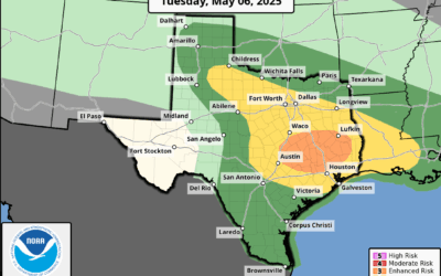
Severe Weather and Flash Flood Threat (5.6.25)
Severe thunderstorms including tornadoes will be possible today mainly north of I-10 Flash flooding also possible. Another severe weather/flash flooding combo day over the region with the main area of concern north of I-10. Strong upper air storm system over NM will...
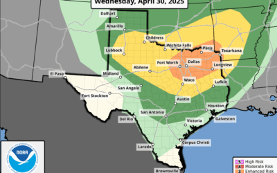
Active Weather Returns
Active weather will return to the area as early as this afternoon and tonight. A thunderstorm complex currently along the Red River will build southward through the day and approach SE TX late this afternoon and evening. Latest high resolution guidance runs show this...

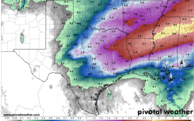
Heavy Rainfall (3-27-25)
Flash Flood Watch has been extended to include Fort Bend and Colorado Counties through Friday evening. Widespread rains…some heavy…likely over the next 24-36 hours. Large upper level storm system over northern MX will move eastward into Texas today and exit the state...

Heavy Rainfall Threat (3-26-25)
Flash Flood Watch in effect Thursday into Friday for Jackson, Matagorda, Wharton, and Brazoria Counties Widespread rainfall…heavy at times…likely Thursday afternoon into Friday. A robust mid level storm system over northern MX will move eastward over the next 2-3...

Heavy Rainfall (Late Week )
Widespread rainfall…some heavy…late this week. In a complete 180 turn from the recent weeks…widespread and significant rainfall is likely Thursday and Friday. A low latitude southern stream storm system will move from northern MX across TX late this week. The position...

Red Flag Warning (3-4-25)
Red Flag Warning has been issued for today for all areas west of I-45. A significant and potentially historic wildfire outbreak is forecasted across a large portion of Texas today SE TX: Overnight data continues to suggest extreme wildfire conditions will develop...

Arctic Cold Front (2-18-25)
Arctic cold front will move across the region this evening. Extreme Cold Watch has been issued for late Wednesday into early Thursday for areas generally along and northwest of US 59 for wind chills below 15 Cold Weather Advisory is in effect from 300am to 1000am...

Potential Cold Air Intrusion (2/14/25)
Significant cold air outbreak mid next week. Surface trough and coastal low forming off the lower Texas coast will move northeast allowing a warm front to move into the area late tonight into Saturday. A few scattered showers may develop this afternoon ahead of the...
Increasing Rain Chances (2-10-25)
Rain chances increase this evening into Tuesday and Wednesday. After what has been a week or longer of record high temperatures a weak cool front has moved into the area overnight. The boundary has reached the coast and pushed offshore with slightly drier and cooler...