Severe thunderstorms including tornadoes will be possible today mainly north of I-10
Flash flooding also possible.
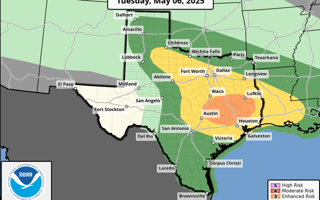
Another severe weather/flash flooding combo day over the region with the main area of concern north of I-10. Strong upper air storm system over NM will shift slowly eastward today with strong deep layer lift spreading into SE TX from the west. Surface warm front currently near/along the I-10 corridor will lift slowly northward through the morning hours and likely will be located along a line from near Brenham to Conroe to Cleveland by noon. The position of the warm front will be critical in the severe weather risk today. Forecast soundings from midday into the late afternoon show enhanced low level shear values north of the metro area near the warm frontal boundary where a higher risk of tornadoes will be found today. Storms are likely to develop by mid to late morning across the northern portions of the area as a low level jet intensifies adding lift to an increasing unstable and sheared air mass. The greatest potential will be along and north of the warm front (mostly along and north of HWY 105), although a more isolated sever threat will exist southward toward the I-10 corridor, but the focus for surface based convection further southward is really not there. High resolution guidance shows this with a fairly sharp cut-off to the activity today with maybe only the northern metro suburbs getting scraped by some storms this afternoon.
Looks to be a brief lull this evening if things go as planned (I am a bit concerned the south edge of the activity could hang up somewhere between HWY 105 and HWY 99 with a period of cell training, but generally conditions will be decreasing with respect to storm favorability toward the early evening hours. Attention will then turn to the southwest where a disturbance will ride northeast out of MX and along the coast late tonight into Wednesday morning. Guidance shows varying degrees of storm development with this feature with the focus this time mostly south of I-10. Severe threat will be lower with this round of storms, but an excessive rainfall threat will be found along the coast into Wednesday afternoon.
Severe:
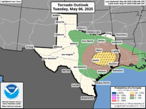
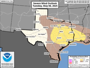
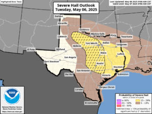
Conditions look pretty favorable today for severe weather north of the metro area and SPC has upgraded the slight (level 2 out of 5) into an “enhanced” level 3 out of 5 risk for today mainly. Warm front will be the main feature to watch for severe and rotating storms. Tornado parameters are certainly there today along the warm front and SPC has increase tornado probabilities into the 10-14% category and outlined that a few of the tornadoes could be strong (EF2 or greater). Warm fronts are notorious for severe and tornado production so this is certainly a threat that should be taken seriously as we do not get many higher end tornado threat days in this area. Damaging winds and large hail will also be possible today.
Risk Parameters N of I-10 today:
Tornado: 10-14% chances with 25 miles of a point (10% probability of EF2 or greater tornado)
Damaging Winds: 15-30% chances with 25 miles of a point
Large Hail: 15-30% chances with 25 miles of a point.
Timing: mid morning to late afternoon
Heavy Rainfall:
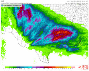
Slow moving warm front with deep tropical moisture in place and potential for cell training along the boundary all spells trouble for flash flooding and heavy rainfall…throw in already wet soils and swollen creeks/rivers and flooding is an increasing concern north of HWY 105. Moisture levels are approaching the 99th percentile this morning and when favorable dynamics come to bear across the area widespread slow moving supercell thunderstorms will be possible near the warm front. Focus will be along and north of the HWY 105 corridor where rainfall amounts of 1-3 inches will be likely with higher totals upwards of 6-7 inches possible. This amount of rain falling on saturated grounds will produce significant run-off and flash flooding. There will be a sharp rainfall cut-off to the south with the activity today. HREF precipitation guidance shows some corridors of 4-8 inches in the Walker, Trinity, Polk County area today and think the upper end bound would be in the 8-10 inch range. Then tonight into Wednesday heavy rains look to focus south of I-10…this area is not as sensitive as areas to the north…but rainfall rates early Wednesday could still result in some flooding.
WPC has our northeast counties with a moderate risk for flash flooding today and the flash flood watch has been extended another row of counties southward to include: Washington, Montgomery, and Liberty. Additional extension of the watch may be needed into Wednesday for areas closer to the coast.
Hydro:
Concern is growing for flooding of creeks and rivers within the San Jacinto basin especially the East Fork, Peach and Caney Creeks with additional rises likely on the lower Brazos and lower Trinity basins. Additional heavy rainfall today may focus on the already high East Fork basin leading to downstream flooding later this week.
This is an interesting weather setup where activity today looks to largely focus north of the Houston metro area and then tonight and Wednesday south.
Forecasted rainfall today
