- Low end chance of tropical development in the northern Gulf mid to late week.
-
Heavy rainfall has once again impacted a large part of the TX Hill Country overnight and this morning with rainfall totals of 2-6 inches and isolated amounts of over 10 inches. This has once again resulted in significant and life threatening rises on normally low flowing or dry creeks and rivers.
San Saba River:
Minor to major flooding is forecasted along the river from Menard TX to below San Saba TX. Flooding in and around San Saba will be similar to what occurred on the July 4 weekend.
Lampasas River:
Major and life threatening flooding is ongoing at Kempner TX with evacuations underway along the river. Flows will moved downstream into Stillhouse Hollow Lake. The lake is currently operating in its flood control pool and storing incoming flood flows.
Llano River:
Minor to moderate flooding is forecasted along the Llano River from Junction to Mason to Llano. While the river has crest at Llano currently, a secondary rise will occur tonight as upstream flood wave is routed downstream. Current forecast keeps the river below major flood levels.
Guadalupe River:
Minor to moderate flooding is possible along the river from the headwaters to Hunt to Kerrville although these forecast are fluid as the rainfall is moving through a bit faster and totals may not reach amounts that would result in the forecasted rises expected at Hunt. Regardless, increased flows and higher than normal waters levels will make conditions in and near the river dangerous as well as low water crossings. All search operations have been suspended and persons, equipment, and vehicles should be moved away from the river.
Canyon Lake:
Incoming flows on the Guadalupe River will be held in Canyon Lake and not downstream releases or floodgate operations will be needed.
Highland Lakes:
LCRA is engaged in flood gate operations a Lake LBJ and Marble Falls to pass incoming flood waves downstream to Lake Travis. Lake Travis will be able to absorb the incoming flows without any floodgate operations. Significant flows and debris are likely on the Highland Lakes through today and into Monday and the lakes are currently closed to recreation.
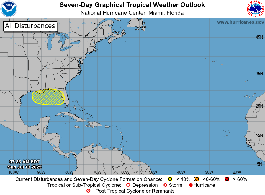
Northern Gulf (mid to late week):
A trough of low pressure off the SE US coast will drift southwest across FL and into the eastern Gulf over the next few days. Visible satellite images this morning suggest that thunderstorms activity may be increasing with this feature. Once in the eastern Gulf by mid week some slow development of this system into a tropical depression will be possible with marginally favorable upper air conditions. There is some probabilities in the various ensemble guidance suggesting some slow development, but where any actual surface low may form is uncertain. Additionally, steering currents look to be weak over this portion of the Gulf which may result in slow and possibly erratic motion.
The National Hurricane Center currently has a 20% chance for development over the next 7 days.
Check weather forecasts daily for updates.
Flash flooding and river flooding ongoing in the TX Hill Country from overnight rains

Houston, TX – sidebar
Houston, US
3:23 am,
Jun 12, 2026
clear sky