- Winter Storm Warning in effect from 600pm Saturday to 600pm Sunday for ice accumulations of .05-.20 of an inch: Harris, Chambers Fort Bend, Wharton, Jackson, Montgomery, Waller, Austin, Liberty, Colorado, Washington, Grimes, and Brazos Counties
- Ice Storm Warning in effect from 600am Saturday to 600pm Sunday for ice accumulations of .25-.50 of an inch: San Jacinto, Polk, Walker, Trinity, Madison, and Houston Counties
- Winter Weather Advisory in effect from midnight to 600pm Sunday for ice accumulations of up to .05 of an inch: Galveston, Brazoria, Matagorda
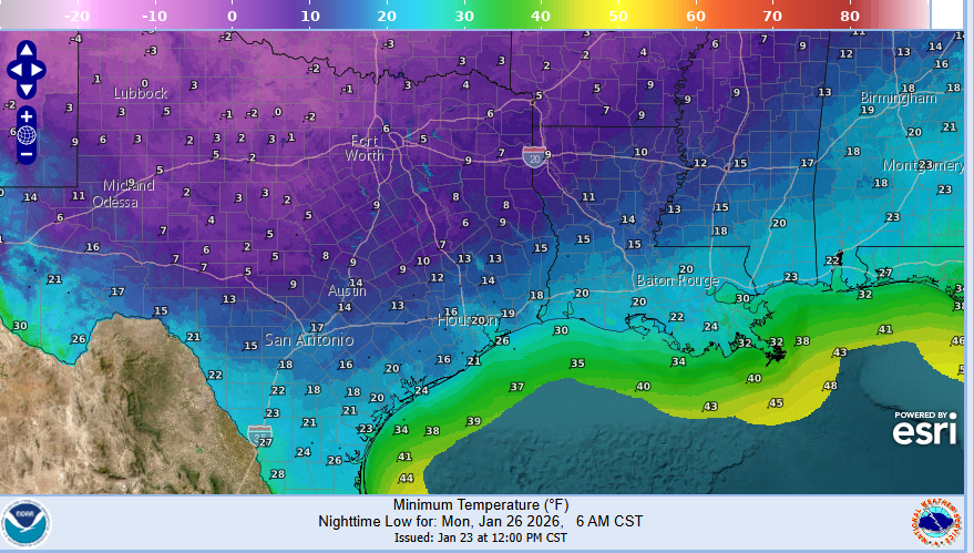
- Extreme Cold Warning in effect from 600pm Saturday to noon Monday for wind chills of -5 to 15 degrees: all counties
Dangerous and potentially damaging cold will be in place especially Monday and Tuesday mornings…maximum winterization preparations must be taken to mitigate infrastructure damage.
There have been no significant changes with the forecast temperatures nor the expected precipitation thus far today. Have added a period from 800am Saturday to midday for the potential for strong thunderstorms and heavy rainfall of 1-2 inches on Saturday. Freezing line will then move southward into Saturday evening and overnight with transition to freezing rain…heaviest and most widespread will come with the strong forcing associated with the upper level trough Sunday morning. Still some uncertainty on exactly when the freezing line reaches certain areas, but high resolution guidance has been a little on the faster side…but not enough to change anything at this point…will watch to see if this is sped up over the next few guidance cycles.
It should be noted that an extremely damaging ice storm is going to impact a large portion of TX north of our region with likely widespread power outages followed by brutally cold temperatures in the 10’s and 1’s for a very large area. This is going to greatly stress critical infrastructure in many areas of the state.
Cold and wind chills Monday and Tuesday mornings will be dangerous…do not underestimate this cold.
- Proper winterization of any exposed pipes/plumbing MUST occur to prevent infrastructure damage. Sprinkler systems must be shut off and properly drained. Exterior facing wall pipes will be a risk of freezing at the forecasted temperatures.
- Pets/livestock will require proper shelter to protect from the cold temperatures and wind chills. Unprotected pets and livestock risk hypothermia and death. Additionally, water sources are likely to freeze over.
- Tropical plants/vegetation will require maximum freeze protection. Unprotected tropical vegetation will be killed and even protect vegetation will likely suffer extensive damage.
- Persons should limit outdoor exposure during the cold. Utilize heating sources properly to reduce the risk of fire and carbon monoxide poisoning.


