
Another storm system will move across the region Saturday into early Sunday
Another storm system will move across the region Saturday into early Sunday A low end severe and heavy rainfall threat is possible from Saturday afternoon to early Sunday morning Much colder air mass to follow into early next week Active weather pattern continues with...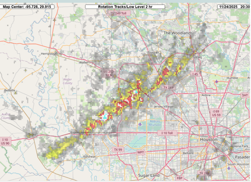
Tornadoes impacted northwest Harris County Monday
Tornadoes impacted northwest Harris County Monday Cool and dry Thanksgiving Wet weather returns this weekend Tornadoes: A cluster of supercell thunderstorms moved across the area late Monday morning into the early afternoon hours resulting it what will likely be at...
Thanksgiving Week Forecast
Another storm system will impact the area Monday afternoon-Tuesday A low end chance of strong to severe thunderstorms Weak cool front has pushed into the Gulf waters with a much drier air mass in place over the region. However, this front is starting to begin a...
A strong cold front will move through the area Saturday night
A strong cold front will move through the area Saturday night Coldest air of the season will arrive into early next week Strong winds and low humidity will bring near critical fire weather concerns Sunday. A little bit of everything for everybody with this...
A strong cold front will move across southeast Texas this afternoon and evening.
A strong cold front will move across southeast Texas this afternoon and evening. There is a marginal risk (level 1out of 5) of severe storms developing along the front from mid-afternoon through early evening. Windy conditions and low tide levels will develop behind...
Line of strong to severe thunderstorms has moved across the area this morning
Line of strong to severe thunderstorms has moved across the area this morning Second round of thunderstorms possible late this afternoon and evening…but conditional on air mass recovering from morning activity Complex of storms that developed over west Texas yesterday...
Houston, TX – sidebar
Houston, US
10:21 am,
Feb 24, 2026
few clouds