
Increasingly Unfavorable Conditions Point Toward a Quiet Remainder of the 2026 Hurricane Season
Updated seasonal hurricane outlooks continue to point toward below- to well-below-normal tropical activity across the Atlantic Basin during the remainder of the 2026 hurricane season.
As we move into the climatological peak of hurricane season — typically August through October — the overall atmospheric pattern across the Atlantic, Caribbean and Gulf of America remains hostile to tropical development.
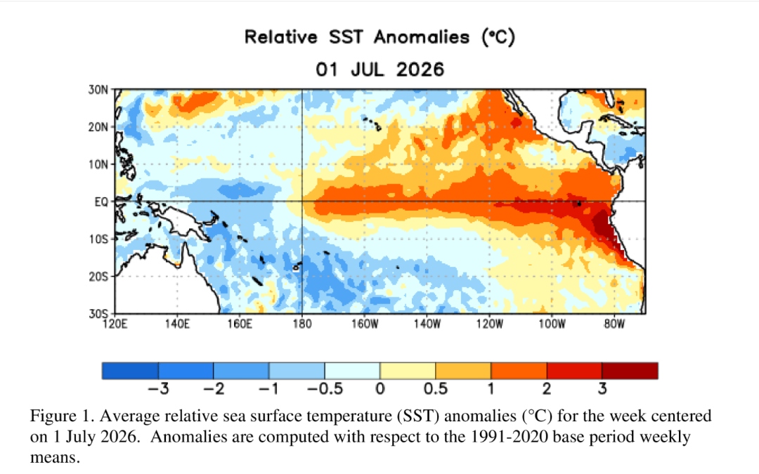
The primary factor behind the increasingly unfavorable outlook is a strengthening El Niño event across the central and eastern Pacific Ocean.
A Strong El Niño Is Becoming the Dominant Climate Signal
Sea surface temperatures across portions of the central and eastern Pacific are currently running 1–3°C above average, with the Niño 3.4 region averaging approximately +2.3°C.
The magnitude of the warming is particularly notable. If current trends continue, this El Niño could become one of the stronger events observed in the modern record.
That matters for the Atlantic because strong El Niño events typically produce an atmospheric pattern that is highly unfavorable for tropical cyclone development.
One of the biggest problems is strong vertical wind shear across the deep tropics.
Wind shear of 40–60 knots has been common across portions of the Caribbean and tropical Atlantic this season. Such strong shear can disrupt thunderstorms near the center of developing tropical disturbances, preventing them from becoming organized tropical cyclones.
In simple terms, the atmosphere is essentially trying to pull developing tropical systems apart.
Strong Wind Shear Is Not the Only Problem
The Atlantic is also dealing with another major inhibitor: dry, sinking air.
Large areas of the Atlantic and Caribbean have experienced persistent dry air and subsidence, limiting the amount of moisture and instability available for thunderstorms.
While sea surface temperatures remain near normal to slightly above normal across parts of the basin, warm water alone does not guarantee tropical development.
A tropical cyclone needs several ingredients to come together, including:
- Warm ocean water
- Sufficient atmospheric moisture
- Persistent thunderstorm activity
- Low vertical wind shear
- Favorable upper-level winds
- A well-defined area of low pressure or disturbance
This season, several of those ingredients have been missing at the same time.
Tropical waves moving westward from Africa have frequently struggled to maintain organization as they encounter the hostile environment across the tropical Atlantic.
2026 Season Numbers Remain Below Average
The Atlantic typically averages around 14 named storms during a hurricane season.
The current Weather Insights projection calls for:
Named Storms: 9 total — approximately 7 additional storms
Hurricanes: 4
Major Hurricanes: 1
Only two named storms — Arthur and Bertha — have developed so far this season. Both systems encountered unfavorable environmental conditions that limited their organization and intensity.
If the current atmospheric pattern continues, 2026 could finish as one of the quietest Atlantic hurricane seasons in decades, potentially comparable to other strong El Niño years such as 1997.
However, a quiet season does not mean a season without hurricanes.
Favorable Windows Can Still Develop
One of the most important points to remember is that seasonal forecasts describe the overall environment, not individual storms.
Even during an otherwise unfavorable hurricane season, there can be brief periods when conditions become supportive of tropical development.
Those windows could become more common during August and September, when the Atlantic climatologically reaches its peak in tropical activity.
A tropical wave that encounters one of these favorable windows could potentially develop into a tropical storm or hurricane — and potentially a strong hurricane — even if the overall season remains well below average.
The Northern Gulf and Southeast U.S. Coast Deserve Attention
Interestingly, conditions have generally been less hostile across the northern Gulf of America and near the southeastern United States compared with the deep tropics.
A persistent trough over the eastern United States has also contributed to recurring areas of low pressure and decaying frontal boundaries extending from the northeastern Gulf toward the Southeast coast.
If that pattern continues through August and September, these areas could become one of the more favorable regions for tropical development.
That is especially important for residents along the Gulf Coast.
A system does not need to develop in the deep tropical Atlantic to become a threat to the Texas or Louisiana coast. A disturbance developing closer to the Gulf Coast can have considerably less time to organize, but it can still produce heavy rainfall, coastal flooding, strong winds and dangerous surf.
The middle Atlantic, particularly areas north of the most hostile deep-tropical environment, could also provide opportunities for tropical waves to develop if they can survive their journey westward.
A Quiet Season Does Not Mean Zero Risk
It is important not to confuse a below-average seasonal forecast with a zero-risk forecast.
Even if the Atlantic produces fewer storms than normal, it only takes one hurricane impacting the Gulf Coast to make the season significant for Southeast Texas.
For residents across Houston, Southeast Texas and the Texas coast, hurricane preparedness should remain a priority throughout the season.
The current outlook suggests that the atmosphere is making tropical development difficult. But tropical weather is highly dependent on timing and location, and conditions can change quickly when a disturbance finds a favorable environment.
Bottom Line
The overall picture for the remainder of the 2026 Atlantic hurricane season remains unfavorable for widespread tropical development.
A strengthening El Niño, exceptionally strong wind shear across the deep tropics, dry air and limited instability are expected to keep a lid on much of the basin.
However, we are entering the heart of hurricane season, and short-lived windows of favorable conditions can still produce dangerous storms.
For Southeast Texas, the message is simple:
Don’t let a quiet seasonal outlook create a false sense of security.
Weather Insights will continue to monitor the Atlantic, Caribbean and Gulf of America for any changes in the large-scale pattern and will provide updates as threats develop.
Stay weather-aware. Stay prepared.
#WeatherInsights #HurricaneSeason #HurricaneSeason2026 #TropicalWeather #AtlanticHurricaneSeason #ElNino #TexasWeather #SoutheastTexas #HoustonWeather #GulfCoast #TXwx