
By Weather Insights | Southeast Texas Weather Outlook
As we head into November, Southeast Texas transitions deeper into fall, bringing cooler mornings, changing temperatures, and periodic opportunities for rainfall. The latest monthly outlook from NOAA’s Climate Prediction Center (CPC) offers insight into the potential temperature and precipitation patterns across the United States, including the broader southern U.S. region.
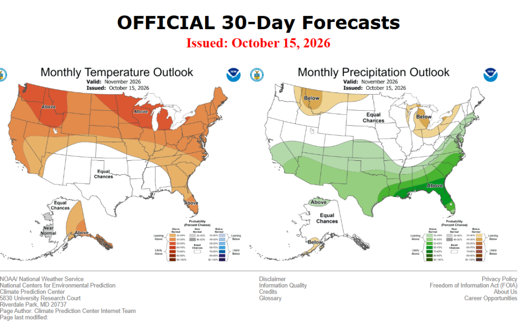
The November outlook, issued October 15, points toward an increased chance of above-normal precipitation across much of the southern United States, while temperature signals are less certain across parts of the southern Plains and Lower Mississippi Valley. These trends provide useful background for Southeast Texas, but they do not guarantee that Houston and surrounding communities will experience a wetter or warmer month.
🌡️ November Temperature Outlook
The CPC favors above-normal temperatures across much of the northern two-thirds of the contiguous United States, with warmer-than-normal conditions also favored along both coasts. However, the temperature outlook is less clear across the southern Plains and Lower Mississippi Valley, where equal chances of above-, near-, or below-normal temperatures are indicated.
For Southeast Texas, this means there is no strong CPC signal favoring one temperature category over another in the current monthly outlook.
November can bring a wide range of temperatures to the Houston area. Warm, humid afternoons can still occur early in the month, while passing cold fronts can deliver noticeably cooler air, lower humidity, and chilly mornings later in the month.
Even if the monthly average ends up near normal, residents should expect temperatures to fluctuate as weather systems move through the region.
🌧️ November Rainfall Outlook
Rainfall is one of the more notable aspects of the November climate outlook.
The CPC indicates an increased probability of above-normal precipitation across much of the southern United States and along the East Coast. However, the discussion highlights uncertainty in the precise location of some precipitation signals, including across parts of the central Plains and Gulf States.
For Southeast Texas, this broader pattern warrants monitoring for periods of increased rainfall during November. However, the monthly outlook does not establish that Houston will receive above-average rainfall, and local conditions may differ from the larger regional pattern.
Rainfall across Southeast Texas is often influenced by the timing and strength of cold fronts, Gulf moisture, and disturbances moving across Texas and the southern United States. A single period of heavy rain can also significantly influence the monthly total.
Importantly, a wetter-than-normal monthly outlook does not mean it will rain every week. Extended dry periods can occur between individual rain events, and rainfall can vary considerably over relatively short distances.
🌎 El Niño and Its Potential Influence
The Climate Prediction Center identifies El Niño as the dominant climate driver influencing its November outlook. The agency notes that El Niño conditions are forecast to strengthen, although November may represent a transition period before some of its broader climate effects become more established during winter.
El Niño occurs when sea-surface temperatures in the central and eastern equatorial Pacific Ocean become warmer than average. These ocean temperature changes can influence atmospheric circulation patterns, affecting the typical distribution of temperature and precipitation across different parts of the United States.
However, El Niño does not determine the weather on any particular day. Its influence varies by region and time of year, and individual cold fronts, storm systems, and Gulf moisture patterns will remain important to Southeast Texas weather.
The CPC also notes that shorter-term atmospheric fluctuations and differences among forecast models introduce uncertainty into portions of the November outlook.
What This Means for Houston and Southeast Texas
Based on the current CPC discussion, the primary takeaway for Southeast Texas is to monitor the potential for rainfall while recognizing that the monthly temperature outlook remains uncertain.
Here are the main points to watch as November progresses:
- Temperatures: Periodic warm afternoons and cooler conditions behind cold fronts are typical for November. The current CPC outlook does not strongly favor above- or below-normal monthly temperatures across the southern Plains and Lower Mississippi Valley.
- Rainfall: The broader southern U.S. outlook favors above-normal precipitation in many areas, but the strength and location of that signal are not uniform. Local rainfall trends will need to be monitored.
- Cold fronts: Passing fronts will continue to play an important role in temperature changes, humidity levels, and opportunities for showers and thunderstorms.
- Changing conditions: The influence of El Niño may become more apparent as we move toward winter, but it will not eliminate the uncertainty associated with individual weather systems.
Residents should continue following shorter-range forecasts for specific rainfall timing, temperature changes, and any potential impacts.
📅 Looking Ahead
The Climate Prediction Center plans to update its November monthly outlook on October 31, providing another opportunity to assess whether the temperature and precipitation probabilities have changed.
Monthly climate outlooks are most useful for understanding broad trends rather than predicting specific weather events. As November approaches, Weather Insights will continue monitoring forecast guidance and local weather patterns to provide updates for Houston and the surrounding Southeast Texas region.
For the latest regional forecasts, weather analysis, and updates, visit Weather Insights.
Official NOAA Resources
- Climate Prediction Center: November 2026 Monthly Outlook Discussion
- Climate Prediction Center: Monthly and Seasonal Outlooks
#WeatherInsights #HoustonWeather #SoutheastTexas #NovemberOutlook #ClimateOutlook