
Prolonged period of cold weather including hard freezes likely next week…cold weather advisory in effect for early Sunday.
Winter storm likely late Monday into late Tuesday
Significant travel disruption with near impossible travel on Tuesday
Cold front will move through the area this morning followed by increasingly colder conditions into Sunday and next week. Clearing skies will help to offset some of the post frontal cooling today followed by a more substantial drop in the temperatures tonight into Sunday. Freezing line will enter the area tonight and make it down toward the north and western sides of the metro area Sunday morning and when combined with gusty northerly winds of 15-25mph wind chills will fall into the 10’s and 20’s for much of the area. A Cold Weather Advisory has been issued for the expected low wind chill values on Sunday morning.
More significant freeze is likely Monday AM with lows into the 20’s for much of the area and into the low 20’s north of HWY 105 with similar lows on Tuesday AM. Potentially the coldest night will be Wednesday morning with possible ice/snow cover and clearing skies resulting in maximum cooling conditions. Guidance continues to resolve this period a bit better with a trending down of low temperatures. Possible much of the area could fall into the upper 10’s with the beaches into the mid 20’s on Wednesday AM.
Other item to consider is the sub-freezing duration of temperatures. Much of the area looks to fall below freezing Monday early evening and not rise above freezing until Wednesday afternoon and even then it may only be a few degrees above freezing for a few hours. This results in sub-freezing duration of potentially 36-45 hours over much of the area and possibly longer.
Monday AM Forecasted Low Temperatures:
North of HWY 105: 22-26
North of I-10: 25-29
Houston metro (inside Beltway): 27-29
Coastal Counties: 28-30
Beaches/Galveston: 31-33
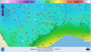
Tuesday AM Forecasted Low Temperatures:
North of HWY 105: 22-26
North of I-10: 26-30
Houston metro (inside Beltway): 27-29
Coastal Counties: 28-30
Beaches/Galveston: 30-32
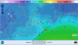
Wednesday AM Forecasted Low Temperatures:
North of HWY 105: 17-20
North of I-10: 18-21
Houston metro (inside Beltway): 19-21
Coastal Counties: 19-24
Beaches/Galveston: 30-32
Maximum preparations and precautions for sub-freezing conditions for many hours should be completed this weekend. Failure to complete proper precautions may result in significant damage to vegetation and infrastructure.
- Protect sensitive vegetation.
- Protect any exposed outdoor pipes (sprinkler systems should be shut off and properly drained). Pipes in attics and along exterior walls of structures could freeze at these levels.
- Prepare proper shelter and warmth for animals and livestock and make sure water sources are not frozen.
- Persons should limit outside exposure to a minimum.
Winter Precipitation:
Once the cold air is in place on Monday an upper level trough will move across the state of Texas late Monday through the day on Tuesday. This feature will force a surface low along the lower Texas coast that will help to draw moisture northward into the cold air mass. Clouds will quickly increase from south to north Monday followed by the development of precipitation late Monday afternoon into the evening hours. The GFS model is slightly warmer at the surface and aloft compared to the ECMWF model resulting in more freezing rain/sleet on the GFS and more snow on the ECMWF. This system is starting to come into the range of our more reliable high resolution models and this should help with both P-type challenges and accumulations over the next 24 hours. Will favor a more snow profile along and north of I-10 with the potential for a mixture of freezing rain/sleet/snow south of I-10. Guidance continues to suggest the potential for mesoscale banding within the precipitation shield that can locally result in much higher totals of precipitation. This has occurred in recent snow events locally in 2004, 2008 and 2009.
Snow accumulations of 1-3 inches is possible along and north of I-10 with locally higher amounts under banding features…lower amounts south of I-10 to the coast with the probabilities of .10 or greater snow now 70-85% for much of the area. Probabilities for .01 or greater ice has increased some south of I-10 into the 35-50% range.
I will continue to caution that the start of this winter weather event is still 72 hours away and changes in the P-type and accumulations are almost certain over that period.
Impacts:
Given surface temperatures will be well below freezing while the precipitation is falling…significant travel impacts can be expected initially on elevated surface and eventually surface streets. Travel disruption late Monday into early Wednesday will be significant and at times potentially impossible over the area. Recovery of area roadways…especially elevated surfaces may be slow depending on the amount of accumulation…it is possible the area is still dealing with travel issues into Thursday morning.
Aviation will be heavily impacted with expected significant delays and cancellations Monday night into Tuesday night. De-icing of aircraft will be required and accumulations on runways is likely

Forecasted Lows Monday Morning
Forecasted Lows Tuesday Morning
Forecasted Lows Wednesday Morning
