Tropical storm likely to become a hurricane.
Discussion:
Rafael has developed a defined low level center over the last 24 hours and has been upgraded to a tropical storm with sustained winds of 60mph. Rafael has turned toward the NW at 13mph. Satellite images show deep thunderstorms across the eastern flank of the system and it appears the tropical storm is developing an inner core structure which will likely allow a period of more significant strengthening into Wednesday.
Track:
Rafael is moving toward the northwest on the southwest side of a large ridge of high pressure over the western Atlantic and this motion will continue for the next 2-4 days bringing the system across the Cayman Islands tonight and into western Cuba on Wednesday before entering the Gulf of Mexico late Wednesday. The track guidance envelope over the next 24-48 hours is tightly clustered and high confidence. The guidance clustering then shows significant spread in the Gulf of Mexico as the vertical depth of the system comes into question along with changing steering flow over the US Gulf coast late this week. The ECMWF and UKMET along with much of their ensembles turn Rafael hard to the right (west) with the system moving toward the central and western Gulf of Mexico, but in a significantly weakened state. The GFS and CMC show less of a hard turn toward the right and a more northwest or north motion with a slowing forward speed over the north-central Gulf off the Louisiana coast this weekend. The official NHC forecast is more in line with the GFS/CMC guidance cluster with a slowing and weakening tropical system off the central US Gulf coast this weekend.
While the forecast track and looks potentially threatening for the NW Gulf of Mexico a cold front is expected to sweep off the TX coast early on Saturday blocking any potential path toward the TX coast.

Intensity:
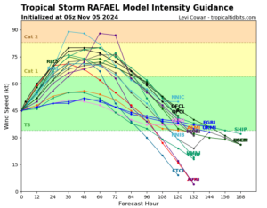
As mentioned, Rafael is likely in the process of forming an inner core this morning and once this process can complete a more rapid intensification process will be possible given very warm waters and light wind shear. Rafael will likely be a hurricane over the Cayman Islands and potentially nearing category 2 hurricane intensity on approach to Cuba. Once in the Gulf of Mexico conditions will generally become less favorable for intensification and more favorable for weakening especially as the system reaches north of 25N by Friday into the weekend. An approaching frontal system over TX will drive strong westerly wind shear over the northern Gulf of Mexico along with dry air. Additionally, recent frontal passages have cooled the waters over the northern Gulf into the low 80’s and upper 70’s which is borderline threshold for tropical systems. Expect a gradual weakening followed by more rapid weakening this weekend. NHC is near the upper end of the intensity guidance cluster at days 4-5 and a more rapid rate of weakening may be needed in future forecasts.
Depending on how quickly the system weakens may influence the track over the central or northern Gulf of Mexico this weekend.

Local Impacts:
Not currently expecting any significant local impacts. Large swells will be created once Rafael reaches the Gulf later Wednesday and these will begin to arrive along the upper TX coast early in the weekend. This is roughly the same time a front will move off the coast and ENE winds will turn toward the north which is not favorable for coastal water level rise. However swells may become large enough to elevate water levels this weekend.


