Cold Friday followed by a wet weekend and then even colder mid next week.
Coastal storm system 1 is existing to the east this morning which brought the widespread rains yesterday. Areas of drizzle remain over the area this morning ahead of s stronger push of cold air that will arrive this afternoon. 1035mb Canadian high pressure cell will move from northern Missouri into northern Arkansas today with a surge of colder and drier air reaching SE TX from the northeast by later afternoon. High temperatures have already occurred for today and a slow decrease followed by a more rapid downward trend can be expected by this afternoon and evening. Typically such an air mass would be able to scour out the clouds, but an active southwest flow aloft with the sub-tropical jet stream reaching from the Pacific across Texas and along the US Gulf coast will keep clouds locked in through the day and likely into tonight. May see brief clearing well up north in the Huntsville and Livingston areas. Even with clouds lingering tonight…solid cold air advection will bring lows into the 30’s and 40’s for much of the area. Freeze line may approach the Livingston area from the northeast but this looks marginal and dependent on decreased clouds in that area.
Friday:
Process begins all over again on Friday as an upper level storm system digs into the SW US and northern Mexico and coastal storm system 2 begins to develop off the lower TX coast. Moisture will increase from the southwest through the day, but will have to fight low level dry air before reaching the ground. Think this process will take into Friday night before light rain and drizzle become more common although would not rule out showers from College Station down to Matagorda Bay by early Friday evening. Given lowering cloud decks on Friday temperatures will go nowhere with highs only slowly warming off morning lows. Some areas may not reach 50 on Friday.
Saturday/Sunday:
Warm front and coastal low lift northward on Saturday with widespread rains developing from southwest to northeast over the area. Warm front will reach into the area Saturday night helping to scour out the low level cold air mass. Much of Saturday will see slowly rising temperatures in the 50’s into the 60’s as the warmer air invades from the south. Stronger lift comes to bear over the region Sunday with the passage of the next front. A line of showers and thunderstorms looks possible at some point with guidance ranging from faster solution Sunday morning to later solutions Sunday evening. This front will be more Pacific in nature, but help scour out the moisture over the region so rainfall chances fall off fairly quickly by Monday.
Early Next Week:
A secondary front will arrive on Tuesday with a cold modified Canadian air mass pushing down the plains and into Texas. This air mass looks to be some of the coldest air thus far this winter season with the potential for freezing temperatures by Wednesday and Thursday morning down toward the I-10 corridor away from the urban heat core.
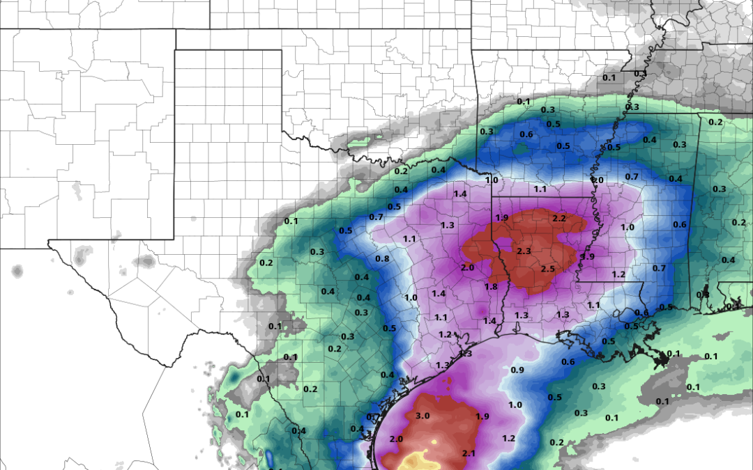
Rainfall Amounts:
Additional rainfall amounts this weekend of 1-2 inches will be common with likely the highest amounts along and east of I-45 where totals could reach 3 inches. Rainfall yesterday was generally less than .50 of an inch over much of the area although some locations to the north and northeast of the metro area recorded 1-2 inches of rainfall. Overall ground conditions remain mostly dry and the area has yet to experience of significant freeze which would increase run-off potential so the upcoming rainfall this weekend should not cause any big concerns.
Marine:
Hazardous marine conditions will be in play today through the weekend with northeast winds increasing 15-25kts and building seas into Friday…followed by a coastal low track across the Gulf waters this weekend. Northeast and easterly winds into Saturday will favor coastal water level rise and could see some minor coastal flooding at times of high tide both Friday and Saturday…possibly into Sunday before winds turn northerly behind a front late Sunday.
