
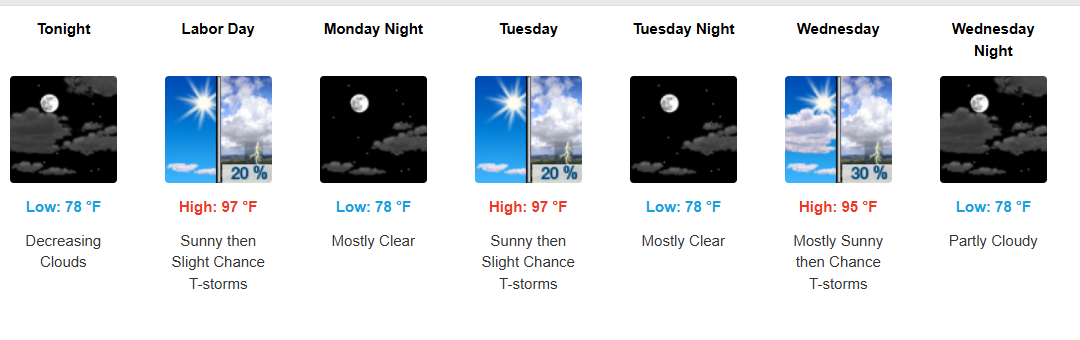
Bottom line: Southeast Texas starts the week stormy and wet, then turns hotter and somewhat drier through midweek. Rain and thunderstorm chances may increase again late in the week, especially along the coast and over the Gulf.
Sunday:
Expect another active day with scattered to widespread showers and thunderstorms. Storms may begin near the coast and Gulf during the morning, then spread inland through the day. Very moist air and weak winds aloft could allow some storms to move slowly and produce locally heavy rainfall, with isolated flooding possible.
Monday–Wednesday:
A building ridge will bring hotter weather and lower rain coverage. Daily isolated to scattered afternoon showers and thunderstorms will remain possible, mainly driven by daytime heating. Inland highs should reach the lower to middle 90s, with heat indices around 102–109°F.
Thursday–Friday:
Rain chances may increase again as a weak disturbance approaches from the Gulf and moisture levels rise. Forecast confidence is lower on the exact timing and strength, but coastal counties and Gulf waters currently appear favored for afternoon showers and thunderstorms.
Next weekend:
The wetter coastal pattern could continue, with periodic showers and thunderstorms possible, especially near the coast and Gulf.
Hazards to watch:
- 🌧️ Heavy rainfall/flooding: Greatest concern Sunday.
- 🌡️ Heat: Increasing Monday–Wednesday, with heat indices potentially reaching 102–109°F.
- ⛈️ Thunderstorms: Possible daily, with the highest coverage Sunday and potentially again late week.
Overall: Stormy Sunday → hotter and somewhat drier Monday–Wednesday → rain chances increasing again late week.
#SoutheastTexasWeather #TexasWeather #HoustonWeather #GulfCoastWeather #WeatherUpdate #weatherinsights