Flash Flood Watch in effect Thursday into Friday for Jackson, Matagorda, Wharton, and Brazoria Counties
Widespread rainfall…heavy at times…likely Thursday afternoon into Friday.
A robust mid level storm system over northern MX will move eastward over the next 2-3 days and across parched areas of southern Texas. The end result will be rounds of showers and thunderstorms. Trends in the last 24 hours in the global model guidance as well as early look at the higher resolution data suggest a heavy rainfall event will unfold late Thursday into Friday from the TX coastal bend/Matagorda Bay region into the southern portions of southeast Texas. Initial disturbance will move out of northeast MX this afternoon with widespread showers and thunderstorms developing over southern Texas and expanding toward our region tonight. Some of this activity may make it into our western counties, but guidance generally shows activity struggling to move eastward much past Matagorda Bay where the formation of a weak trough axis and convergence zone will be found.
As the mid level trough moves east into Texas on Thursday a surface low is likely to form along the trough axis while that feature becomes oriented more southwest to northeast along the mid TX coast into the southwest portions of our area (say toward the Wharton area). Tropical moisture currently noted over the western Gulf will quickly advance northward today and interact with these features helping to feed higher rainfall intensities into Thursday night and Friday. Main period of concern locally will come Thursday night into Friday when it appears slow moving and potentially training thunderstorms will develop ahead of the weak surface low exiting the Matagorda Bay region and sliding eastward. This period is mostly just outside of the higher resolution guidance runs…but runs going into Thursday evening currently show only spotty activity over the area. It is interesting that the higher resolution guidance is coming in drier than the global guidance…this same situation was noted Sunday into Monday and the wetter global guidance was more correct with what happened. Parameters are certainly in place for heavy to excessive rainfall over the area Thursday night into Friday with the current thinking that the heaviest rains and highest flash flood threat will remain southwest of the Houston metro area (say south of I-10). We are getting to the time of year where mesoscale processes tend to dictate a bit more and these types of setups can result in very large differences in rainfall totals over a short distance. Where any repeat cell training becomes established significant rains and flash flooding will be possible with areas nearby potentially experiencing much lower rainfall values.
Rainfall Amounts:
Widespread rainfall amounts of 2-3 inches can be expected over much of the area with isolated totals of 8-10 inches around Matagorda Bay. WPC has placed all areas south of I-10 in the slight (level 2 out of 4) risk for excessive rainfall and flash flooding on Thursday and areas east of I-45 in a slight risk for Friday. While soils are dry the potential for sustained convection with hourly rainfall rates of greater than 2.0 inches raises concern for rapid run-off. Think these greatest totals will remain southwest of the metro area. This may be a situation where sustained storms near the coast “rob” moisture from inland areas and keep the heaviest rainfall focused along the coast or offshore.
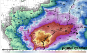
Forecast Rainfall Totals Wednesday-Friday
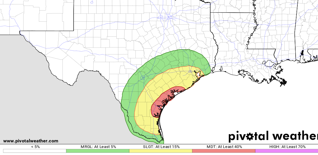
Severe Threat:
A marginal and slight (level 2 out of 5) severe threat has also been added to the area for strong to severe thunderstorms capable of producing wind damage and hail for Thursday into Thursday night. Greatest threat will be roughly south of I-10 and leaning more toward a wind threat as the saturated profiles usually do not support much of a hail threat.

Storm Prediction Center Severe Weather Outlook for Thursday
