Increasing showers and thunderstorms today-early Tuesday as a cool front moves across the area.
Coastal Flood Advisory is in effect for the entire upper TX coast today.
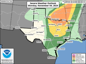
Radar early this morning showers scattered showers racing northward over the area as has been the case since Saturday with the best concentration along and east of I-45. This activity will continue through the day and expand in coverage and intensity through the afternoon hours will some modest heating and the eventual approach of a frontal system late tonight into early Tuesday. Forecast guidance continues to point toward an active period of weather with the incoming frontal boundary tonight into early Tuesday with parameters favorable for the formation of a line of showers and thunderstorms. Some of these storms could become severe and SPC has outlooked the northern portions of the area in a slight (level 2 out of 5 risk) with the rest of the area in a marginal (level 1 out of 5 risk) for severe thunderstorms tonight. The main threat will be damaging winds and large hail although an isolated tornado is possible. Front should reach the College Station area around midnight, the Houston metro between 3-6am and the coast around sunrise. Front looks to slow and eventually stall near the coast or just offshore Tuesday afternoon and this may linger scattered showers along the coast well into Tuesday afternoon while inland locations dry from north to south through the day. Heavy rainfall also looks possible with a sustained low level jet overhead supplying moisture from the Bay of Campeche, although the main thrust of lift will be sliding toward the north with time, so expect the line of showers and thunderstorms to weaken toward the coast Tuesday.

Strong southerly winds have resulted in elevated tides and this will continue today with water levels at times of high tide reaching minor flooding levels along the Gulf facing beaches. South winds today of 20-30mph with higher gust will be common with the low level jet overhead. Weakening winds tonight into Tuesday should help lower seas and reduce the water level run-up on the coast.
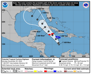
Front will remain stalled near the coast through mid week while PTC 18 comes northwest out of the Caribbean Sea and toward the central Gulf of Mexico likely as a hurricane. Guidance continues to suggest a track of a tropical system into the north-central Gulf this weekend…while rare it is not totally unheard of for early November. Broad wind field associated with the system will likely begin to impose along the upper TX coast by late this week into the weekend with winds becoming ENE/NE and increasing along with building seas. Upper level wind shear over the US Gulf coast will likely greatly weaken any tropical system prior to reaching the US coast.


