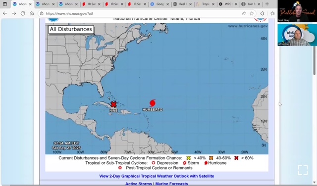
PTC 9:
Surface observations and satellite data indicate that a low level circulation is becoming more well defined in association with the tropical wave over eastern Cuba and the Bahamas this morning. If this organization trend continues it is likely a tropical depression will form in the next 12-24 hours. The system is moving toward the NW around 5mph and a turn toward the NNW with a slow forward speed is expected through the weekend.
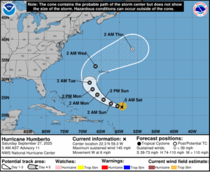
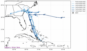
 While Guidance is in decent agreement on the track of PTC 9 through the weekend, there is significant divergence early next week. The majority of the guidance and the ensemble members now slow the system and turn it eastward due to interaction with powerful hurricane Humberto to the east before making landfall on the US SE coast. This trend appears to be a function of a slower northward track and more influence from Humberto than previous guidance had suggested. There is considerable uncertainty in the track forecast early next week due to the complex steering over the SE US and additional changes in the forecast will be possible.
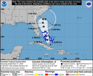
Gradual intensification will be possible with PTC 9 over the weekend as it lifts northward through the Bahamas, but southerly shear and some dry air lurking to the west may help to cap an otherwise favorable environment. The system could reach hurricane intensity early next week between the Bahamas and the SE US coast.
While PTC 9 is currently not forecast to make actual landfall, widespread impacts area expected along the Carolina and GA coasts much of next week including gusty winds, very heavy rainfall and flash flooding, and coastal storm surge.
