- Winter Storm Watch has been issued from Saturday through Sunday afternoon for all of SE TX except the coastal counties
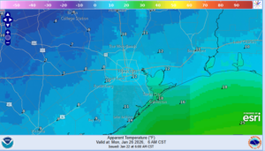
- Dangerously cold temperatures and wind chills this weekend into early next week.
- Chances for freezing rain and ice accumulation for Houston metro Saturday night and Sunday
- Maximum winterization preparation will be needed for this event to help mitigate infrastructure damage…completed by Friday afternoon.
***Changes***
Forecast trends in the last 24 hours have delayed the onset of the “real” cold air and freezing temperatures to later on Saturday most likely into the evening hours of Saturday. Threat of freezing rain during the day Saturday is lowered in favor of Saturday evening into overnight Sunday morning. Additionally, a Hard freeze Sunday morning is looking less likely with temperatures in the mid 20’s to near 30. Hard freezes for Mon AM and Tues AM remain in the forecast unchanged.
Frontal Timing:
Still looking at an initial surge of cooler air on Friday evening, which will bring temperatures into the 40’s overnight into Saturday. However, it is a secondary push of the arctic air mass on Saturday which will drive temperatures below freezing and this now looks to occur Saturday evening into the overnight hours. There remains even at this range uncertainty on when this surge of colder air moves southward and its intensity.
Temperatures:
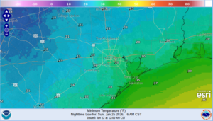
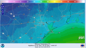
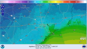
- Hard freezes for much of the area is likely Mon and Tues mornings with a widespread freeze on Sun morning.
- Temperatures will likely remain below/near freezing on Sunday and may only briefly push above freezing on Monday.
Once the area falls below freezing Saturday evening a prolonged period of sub-freezing temperatures in likely with durations potentially exceeding 30-40 hours over the metro area and 50-60 hours north of HWY 105.
North of HWY 105:
Sun AM: 20-23
Mon AM: 14-18
Tues AM: 15-20
North of I-10
Sun AM: 25-30
Mon AM: 18-23
Tues AM: 21-25
South of I-10:
Sun AM: 26-31
Mon AM: 20-24
Tues AM: 22-27
Precipitation:
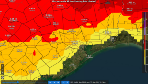
- Freezing rain remains likely especially north and west of the metro area Saturday night and advancing toward the I-10 corridor and possible the coast on Sunday.
- Ice accumulation remains likely north of I-10/US 59 Saturday night into Sunday…there is greater uncertainty south of I-10 of icing on Sunday
- Travel impacts are likely on elevated bridges, overpasses, flyovers, and connector ramps late Saturday into Sunday and possibly lingering into Monday.
Delayed onset of the freezing line into Saturday evening will delay the onset of the potential for freezing rain over much of the area. Guidance is still in general agreement that the freezing line advances southward during the night into Sunday morning with rain changing to freezing rain. How quickly this happens remains in question and the early incoming high resolution guidance have come in slower on the arrival of the cold air similar to the trend in the global models the last 24 hours. Widespread rain and shower is likely Saturday with a lull possible Saturday evening before another round of rainfall on Sunday morning into the early afternoon…it is this second round that will be most concerning as a large part of the region will likely be below freezing by this point and we could see some periods of moderate or heavy precipitation Sunday morning.
Accumulations:
Storm event accumulations range from .05 to .25 of an inch from the US 59/I-10 corridor northward with the highest amounts found north of HWY 105 where a longer overlap of freezing temperatures and precipitation is most likely. South of I-10 amounts could range in the .01 to .05 range. While these amounts may seem low, it only takes a very small amount of ice to create extremely hazardous driving conditions on bridges and overpasses.
.25 of an inch of ice is generally when power outages and tree damage begin to occur (think these amounts will be further north toward College Station and Huntsville)
Potential Ice Accumulations:
North of HWY 105: .10-.25
North of I-10/US 59: .05-.10
South of I-10/US 59: .01-.05
Gusty north winds of 15-20mph through the period will add additional stress to ice coated trees and power lines and isolated power outages will be possible.
Preparations:
- Proper winterization of any exposed pipes/plumbing will be needed to prevent infrastructure damage. Sprinkler systems must be shut off and properly drained. Exterior facing wall pipes will be a risk of freezing at the forecasted temperatures.
- Pets/livestock will require proper shelter to protect from the cold temperatures and wind chills.
- Tropical plants/vegetation will require maximum freeze protection. Unprotected tropical vegetation will be killed and even protect vegetation will likely suffer heavy damage.
- Persons should limit outdoor exposure during the cold. Utilize heating sources properly to reduce the risk of fire and carbon monoxide poisoning.
All cold weather preparations should be completed by Friday afternoon. While temperatures will be above freezing on Saturday during the day off and on showers and rain will make outdoor preparations more difficult.
Forecast Low temperatures (Sun AM):