- Hurricane watch in effect from High Island TX to Cameron LA
- Tropical Storm Warning in effect from High Island TX to the Cameron/Vermillion Parish line
- Storm Surge Warning in effect from High Island TX to the Cameron/Vermillion Parish line
- Flood Watch in effect until 700am Wednesday (Fort Bend and Brazoria Counties have been added to the watch)
- Heavy rainfall and flash flooding will be possible Tuesday along and east of the I-45 corridor and Tuesday night north of I-10
- Gusty winds along the coast of Bolivar Tuesday morning spreading inland over Chambers, Liberty, eastern Harris, and eastern Montgomery County Tuesday afternoon and evening
- Minor coastal flooding along the Gulf beaches on Tuesday
Discussion:
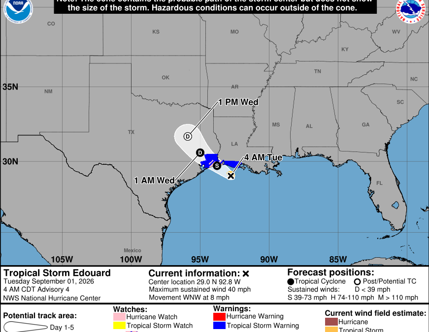
USAF mission last evening found a pressure drop in Edouard down to around 1004mb, but since then the pressure has leveled off around 1005mb. Radar from Lake Charles shows a well defined tropical storm with several banding features and a small inner core feature that at times has resembled the formation of an eyewall structure. Next aircraft will be in the system later this morning. Maximum sustained winds remain near 40mph and Edouard is very small with tropical storm force winds only extending outward about 25 miles from the center. Land based radar indicates the tropical storm is moving toward the WNW around 7-8mph.
Track:
Edouard will continue on a WNW to NW heading through the day bringing the system to landfall over Jefferson County TX between High Island and Sabine Pass. The system will then continue inland over SE TX into tonight on a general NW track toward the Conroe/Huntsville area by Wednesday morning and then into north-central Texas on Thursday. There has been little change to the overall track reasoning and NHC is close to the multi-model consensus.
- Remember that a tropical system is not a point and the location of landfall does not indicate where impacts will be felt. Impacts will extend well inland along and either side of the track and well away from the center.
Intensity:
Edouard is in a good environment for intensification and will continue to organize into landfall. Thus far there has been no significant pressure falls since the initial decrease yesterday evening, but several guidance models insist that Edouard will rapidly intensify in the last 4-6 hours before landfall. Once inland a decrease in wind looks fairly quick, but guidance holds on to a well defined circulation well inland over TX into Wednesday and even Thursday and this is likely due to the good upper level conditions aloft.
Impacts:
Rainfall:
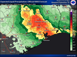
Corridor of heavy rainfall is increasingly likely from Jefferson County and Galveston Bay NW across the area mainly along and east of the I-45 corridor today into this evening. Rainfall amounts of 3-6 inches is likely over Chambers, Liberty, San Jacinto, eastern Montgomery, eastern Harris and eastern Galveston Counties with isolated totals upwards of 6-9 inches. As the circulation moves to the NW into early Wednesday banding features may develop further west of the area…and some of the latest high resolution guidance suggest areas west of I-45 and north of I-10 could see heavy rainfall late tonight into Wednesday with bands on the southern side of the circulation. While rainfall today west of I-45 will be limited, totals have been increased for late tonight into Wednesday north of I-10 and west of I-45 for heavy rainfall in banding features.
- Given the setup…it is likely some areas will experience several inches of rainfall in bands, while other nearby areas see significantly lesser amounts.
Hydro:
Most concerned with the eastern watersheds…Luce Bayou, Cedar Bayou, Goose Creek, East Fork of the San Jacinto River as this is where the likely highest rainfall amounts will focus on the track of the system is down the length of the south to north watersheds. Can’t rule out some significant rises or rises to minor flood levels on these channels. Further west some rises on creeks and bayous can be expected especially with any cell and band training that may occur late tonight into Wednesday. Concern does increase for the West Fork of the San Jacinto River, Spring, Willow, Little Cypress Creek watersheds late tonight into Wednesday as guidance has been hinting at higher rainfall totals on the southern flank of the circulation during that timeframe.
Winds:
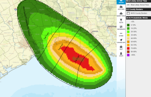
Given the small wind field associated with the system tropical storm force winds will likely only impact the eastern portions of Chambers and Liberty Counties where the probability of sustained tropical storm (40mph) winds is in the 20-30% range. Most of the area will experience winds on the order of 15-25mph with some higher gusts in fast moving squalls.
Tides:
Some minor coast flooding will be possible on Tuesday mainly along Bolivar where larger swells off the Gulf will be possible. Depending on the exact track of the center gusty E/NE winds across Galveston Bay may result in 1-2 feet of elevated tides on the west side of the Bay on Tuesday and when combined with increasing wave action some minor flooding will be possible at the usual low lying areas (Toddville Rd, Seabrook, Shoreacres, and around the Lynchburg Ferry Landing). Storm surge flooding of 2-4 feet above normal dry ground will be possible east of High Island including Sabine Lake. Overwash is increasingly likely on the eastern end of HWY 87