
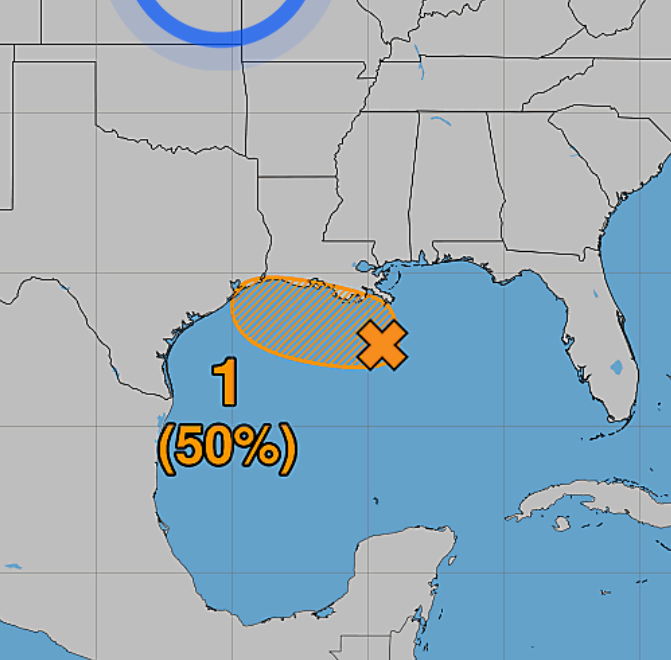
The National Hurricane Center has increased the chance of tropical development in the northern Gulf of America to 50% through the next 48 hours and 50% through 7 days.
A low-pressure system, designated AL97, is currently about 125 miles south of southeastern Louisiana and has become better organized. The system is expected to move slowly west-northwestward, with a possible short-lived tropical depression or tropical storm developing before reaching the Upper Texas or southwestern Louisiana coast Tuesday or Tuesday night.
🌧️ What could Southeast Texas see?
Even if the system does not become a named tropical storm, the main concern for our area is locally heavy rainfall.
• Periods of heavy rain and thunderstorms
• Locally intense rainfall that could produce street/urban flooding
• Gusty winds, particularly near heavier storms
• Reduced visibility and difficult driving conditions
• Potentially higher rain totals in localized areas
⚠️ The exact impacts are NOT known yet. Small changes in the track or development of this system could significantly affect where the heaviest rain falls.
Residents along the Upper Texas coast should continue monitoring updates over the next 24–48 hours. Now is a good time to make sure you have multiple ways to receive weather alerts and to review your flood/emergency plans.
Bottom line: Don’t focus solely on whether this becomes a tropical storm. Heavy rainfall could be the biggest concern for Southeast Texas regardless of development.
We’ll continue watching AL97 closely and sharing updates as the forecast becomes clearer. 🌴🌧️
#SoutheastTexas #TexasWeather #TropicalWeather #GulfOfAmerica #AL97 #HoustonWeather #TropicalUpdate #Weatherinsights
Podcast: Play in new window | Download