Weekend:
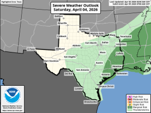
Stronger front heads into the area late Saturday and expect a line of showers and thunderstorms to develop and cross the area Saturday afternoon and evening. Widespread moderate to at times heavy rainfall will be possible with this activity given the moisture profiles in place. Overall severe threat is low with lacking instability but the areas has been included in a level 1 out of 5 risk for Saturday. Front may linger near the coast into Sunday keeping at least a chance of showers going along the coast and possibly as far north as the I-10 corridor.
Rainfall:
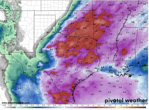
Much of the area has seen degrading of drought conditions over the last few weeks and widespread rainfall is desperately needed. Water supply lakes (especially southwest) are starting to show significant drought related stress with Lake Texanna down to 53% of full capacity. Widespread rainfall amounts of 1-2 inches are likely today through the weekend with the highest totals north of I-10 and lowest toward the coast. Again…this is much needed rainfall and not flooding is expected.
Much cooler Sunday into early next week with lows into the 40’s/50’s and highs in the 70’s.