- Significant Witner Storm to impact the state and region over the next 24-36 hours.
- Significant travel impacts are likely across the region and state.
- Dangerous and damaging cold likely Monday and Tuesday mornings
- Preparations for this cold weather event should be completed.
Timing:
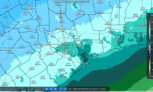
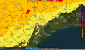
Freezing line is advancing through Texas this morning and currently extends from Dallas to just northwest of San Antonio. Northwest of this line freezing rain and sleet are covering a large portion of NW/W/ and N TX and this mixed precipitation will move southward through the day. Freezing line may be running a little but faster than expected, but not enough to change any of the timing. Freezing line is likely to reach the College Station to Huntsville area mid to late afternoon and a Columbus to Conroe line by early evening then down to the US 59 corridor late evening and on to the coast early Sunday.
Temperatures:
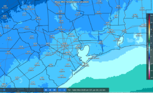
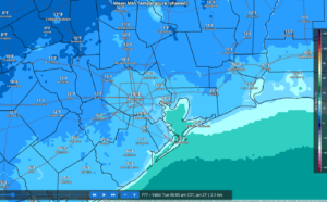
- Potentially damaging hard freezes are likely Mon and Tues AM
- Many hours at or below freezing is expected across much of the region which will worsen the impacts of the extremely cold temperatures
Once the area falls below freezing Saturday evening a prolonged period of sub-freezing temperatures is likely with durations potentially exceeding 30-48 hours over the metro area and 60-72 hours north of HWY 105. It is increasingly likely many areas will not rise above freezing on Sunday and only briefly on Monday.
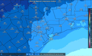
Wind chills will fall to dangerous levels Sunday into Monday with values below 0 north and west of the metro area and 1’s elsewhere…do NOT underestimate this cold.
North of HWY 105:
Sun AM: 21-24
Mon AM: 13-16
Tues AM: 14-16
North of I-10
Sun AM: 25-31
Mon AM: 14-21
Tues AM: 14-21
South of I-10:
Sun AM: 27-32
Mon AM: 18-22
Tues AM: 17-22
Precipitation:
- Freezing rain remains likely especially north and west of the metro area Saturday night and advancing toward the US-59 corridor and to the coast on Sunday
- Ice accumulation is likely across much of the area with the highest amounts to the north and west.
- Travel impacts are likely on elevated bridges, overpasses, flyovers, and connector ramps late Saturday into Sunday and lingering into Monday.
Ongoing showers and thunderstorms this morning with heavy rainfall will move east of the area over the next few hours. Scattered light rain and showers will continue into the afternoon hours. Another round of showers and thunderstorms will develop across the area later tonight into early Sunday. As the freezing line advances southward tonight into Sunday morning a transition to freezing rain is likely for much of the area along with accumulations of ice.
Accumulations:
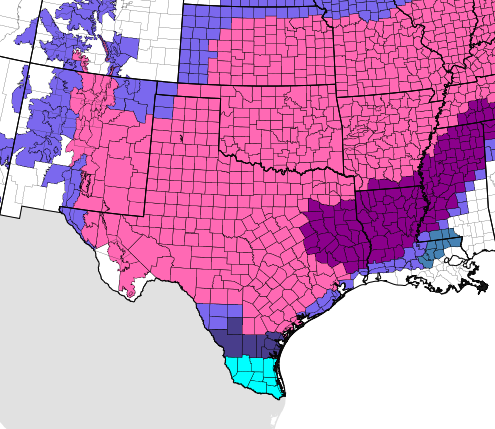
Storm event accumulations range from .05 to .25 of an inch from the US 59/I-10 corridor northward with the highest amounts found north of HWY 105 where a longer overlap of freezing temperatures and precipitation is most likely. South of I-10 amounts could range in the .01 to .05 range. While these amounts may seem low, it only takes a very small amount of ice to create extremely hazardous driving conditions on bridges and overpasses.
.25 of an inch of ice is generally when power outages and tree damage begin to occur. Damage to trees and power lines is likely in the Ice Storm Warning area where accumulations of .30-.50 will be possible.
Potential Ice Accumulations:
North of HWY 105: .25-.40
North of I-10/US 59: .05-.20
South of I-10/US 59: .01-.05
Additionally, gusty winds of 15-25mph will add stress to ice covered tree limbs and powerlines.
Preparations:
- Proper winterization of any exposed pipes/plumbing MUST occur to prevent infrastructure damage. Sprinkler systems must be shut off and properly drained. Exterior facing wall pipes will be a risk of freezing at the forecasted temperatures.
- Pets/livestock will require proper shelter to protect from the cold temperatures and wind chills. Unprotected pets and livestock risk hypothermia and death. Additionally, water sources are likely to freeze over.
- Tropical plants/vegetation will require maximum freeze protection. Unprotected tropical vegetation will be killed and even protect vegetation will likely suffer extensive damage.
- Persons should limit outdoor exposure during the cold. Utilize heating sources properly to reduce the risk of fire and carbon monoxide poisoning.