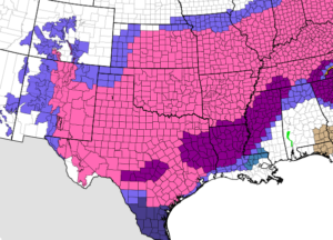
- Significant Winter Storm to impact the state and region over the next 24-36 hours.
- Significant travel impacts are likely across the region and state.
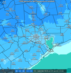
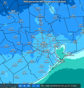
- Dangerous and damaging cold likely Monday and Tuesday mornings
- Preparations for this cold weather event should be completed
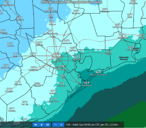
Freezing line currently extends from Crockett to Madisonville to Giddings and is progressing southeast and will move into the Houston metro area through the evening hours.
The following timing looks to be the onset of freezing temperatures across the metro area tonight:
Conroe to Hempstead: 500-700pm
Magnolia to Hockley to Brookshire: 600-800pm
Spring to Jersey Village to Richmond: 1000pm-midnight
Pearland to Baytown: 200am- 400am
Bay Area: 400am-600am
Precipitation:
- Freezing rain is likely especially north and west of the metro area Saturday evening and advancing toward the US-59 corridor and to the coast on Sunday
- Ice accumulation is likely across much of the area with the highest amounts to the north and west.
- Travel impacts are likely on elevated bridges, overpasses, flyovers, and connector ramps late Saturday into Sunday and lingering into Monday.
Scattered light rain and showers have continued this afternoon with the main storm system over Baja starting to turn east and will move across MX and TX tonight into Sunday. There will be a corresponding increase in lift across the area this evening into Sunday morning with the development of widespread showers and a few thunderstorms. This will occur as the freezing line advances southward resulting in freezing rain and ice accumulation. A few of the stronger cells could produce some sleet mixed with freezing rain. Precipitation will end Sunday morning in the 800-900am although some drizzle and mist may continues into the early afternoon hours and humidity levels look to remain in the 75-95% range which will slow the drying of any wet pavement that is not frozen.
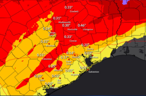
Accumulations:
Storm event accumulations range from .05 to .25 of an inch from the US 59 (southwest of Houston)/I-10 (east of Houston) corridor northward with the highest amounts found north of HWY 105 where a longer overlap of freezing temperatures and precipitation is most likely. South of I-10 amounts could range in the .01 to .10 range and the Winter Storm Warning has been extended southward in inland Matagorda and Brazoria Counties. While these amounts may seem low, it only takes a very small amount of ice to create extremely hazardous driving conditions on bridges and overpasses.
.25 of an inch of ice is generally when power outages and tree damage begin to occur. Dmaage to trees and power lines is likely in the Ice Storm Warning area where accumulations of .30-.50 will be possible.
Potential Ice Accumulations:
North of HWY 105: .25-.40
North of I-10/US 59: .05-.25
South of I-10/US 59: .01-.10
Additionally, gusty winds of 15-25mph will add stress to ice covered tree limbs and powerlines.
Little recovery is expected on Sunday after the precipitation ends with cloud cover lingering. Any melting of ice will refreeze overnight along with areas patches of water from the recent rainfall (even on surface streets and parking lots).