A significant winter storm will likely impact large portions of the state this weekend
Very cold temperatures and wind chills likely this weekend
Winterization protection measures for hard freezes and prolonged cold should be completed by Friday afternoon.
Strong arctic cold front driven by sprawling surface high pressure in the 1048-1051mb range will move out of Canada late this week with the boundary arriving in Texas on Friday. Classic arctic front will progress across the state on Friday with significant post frontal temperature falls and rapid advancement of the freezing line southward. Front looks to reach SE TX in the evening hours on Friday, but this may be too slow given these fronts tend to move south faster than guidance suggests (probably wont have a better idea on frontal timing until Thursday when we get into range of the high resolution guidance). Temperatures will quickly fall Friday night into Saturday morning with the freezing line advancing toward the Columbus to Conroe corridor by sunrise on Saturday…this also may need to be adjusted southward some in the coming days. Cold air continues to pour southward Saturday with likely slowly falling temperatures through the day with the freezing line advancing toward the I-10 corridor Saturday evening and likely toward the coast by Sunday morning. Again…will need to watch temperature trends closely as this current timeline could be too slow bringing the freezing line south.
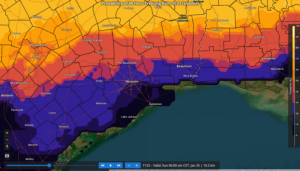
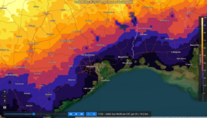
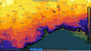
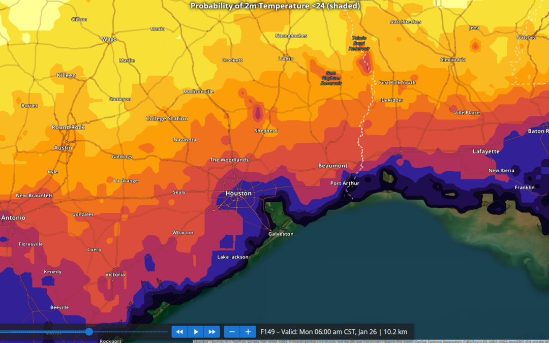
Hard freezes look increasing likely for areas north of I-10 Sunday AM and for a larger part of the area Mon AM including the Houston metro area. National Blend of Models has continued a slow decrease in both highs and lows for this period with potential for mid to upper 20’s Sunday AM for much of the metro area and low 20’s Mon AM (see graphics below). Highs on Sunday may struggle to reach the mid 30’s and this would only be for a few hours…some places will likely not reach above freezing on Sunday…yielding a prolonged period of sub-freezing temperatures. Wind chills Saturday into Sunday are likely to fall into the 10’s and 20’s across much of the area with north winds of 10-20mph.
Precipitation:
A significant winter storm looks to impact much of the state late Friday into Sunday with accumulations of ice and snow.
SE TX is likely to lie on the southern edge of an upcoming winter storm with widespread post frontal precipitation occurring from Friday night through Sunday morning. Forecast sounding suggest a warm layer of air above the cold dense surface air resulting in a profile favorable for the production of freezing rain where surface temperatures fall to 32 and below. By Saturday morning this line is roughly from Columbus to Conroe (maybe a bit further south) with locations north of this line potentially experiencing freezing rain and icing. Through the day Saturday into Saturday evening with the freezing line sinking southward the freezing rain/drizzle could move toward the I-10 corridor although there is a fair amount of uncertainty on how quickly the moisture begins to move out and does that happen before the surface air is cold enough to support freezing rain further southward into the metro area. For what it is worth at this point the National Blend of Models has freezing rain probabilities Saturday night into Sunday morning of 30-40% in NW Harris County and 20-30% as far south as the US 59 corridor (see graphics below).
It should be noted that travel across large portions of the state from late Friday through much of the weekend will become extremely dangerous due to winter precipitation accumulations and brutal cold.
Preparations:
- Proper winterization of any exposed pipes/plumbing will be needed to prevent infrastructure damage. Sprinkler systems must be shut off and properly drained.
- Pets/livestock will require proper shelter to protect from the cold temperatures and wind chills.
- Tropical plants/vegetation will require maximum freeze protection. Unprotected tropical vegetation will be killed and even protect vegetation will likely suffer heavy damage.
- Persons should limit outdoor exposure during the cold. Utilize heating sources properly to reduce the risk of fire and carbon monoxide poisoning.
All cold weather preparations should be completed by Saturday afternoon prior to the arrival of the cold front.
Freezing Rain Probabilities (Sat 600pm):