- A cold front will bring a chance of isolated strong to severe thunderstorms to the region today and this evening
- Damaging winds and large hail will be the main threats although an isolated tornado can’t be ruled out
An upper level storm system moving out of northern New Mexico Water Vapor Satellite Loop for Atlantic/EPAC Combo | Tropical Tidbits this morning along with an incoming cold front from the north will combine with the high levels of moisture and warmth over the area to produce a chance of showers and thunderstorms today. First round of showers and thunderstorms is likely later this morning into the midday hours with this activity generally shifting toward the north and northeast and maybe a brief lull during the early afternoon before better lift comes to bear across the area in the mid to late afternoon and evening hours along with the actual frontal boundary this evening.
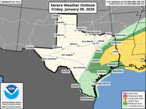
Severe Threat:
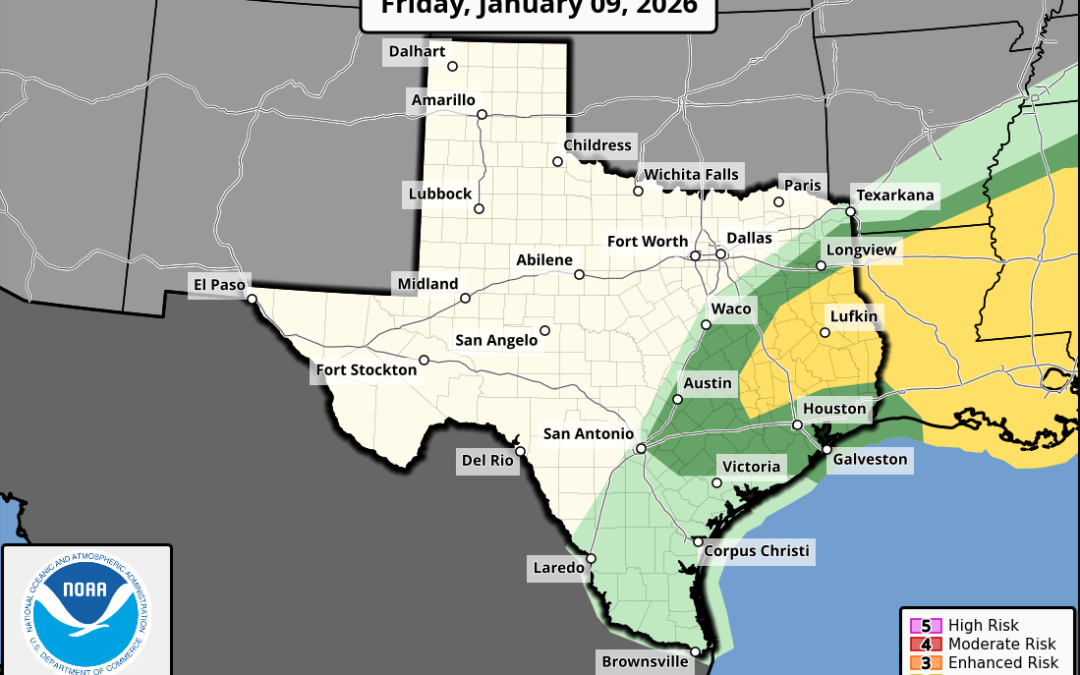
The highest severe threat will be north of the Houston metro area (College Station, Conroe, Livingston) where SPC has placed a slight risk (level 2 out of 5) for severe thunderstorms (hail greater than 1 inch in diameter and or wind of 58mph or greater) along with isolated tornadoes. South of the slight risk there is a marginal risk (level 1 out of 5) risk to the coast for severe thunderstorms. While wind profiles are favorable for severe thunderstorm development, instability or energy may be lacking some this afternoon keeping the threat more isolated in nature. Will need to monitor how showers and cloud cover behaves through the early afternoon as a bit more sun and heating would help add more energy than expected to the atmosphere.
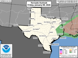
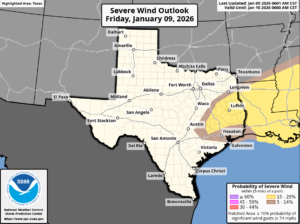
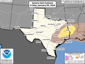
Main severe threat will be large hail and damaging winds and leaning a bit more toward hail given cooling temperatures aloft with the approaching upper level system. However, wind profiles do support storm rotation especially any discrete cells that are able to develop out ahead of the incoming cold front. While the tornado risk is low it is not zero and the threat is generally greater eastward into Louisiana.
Main timing for any severe weather will be from 300-400pm through 1000-1100pm this afternoon and evening from northwest to southeast across the region.
Weekend:
Cold front will usher in a much colder and drier air mass through the weekend with highs near 60 instead of the recent near 80 degree days and lows in the 40’s. Winds will be gusty from the north on Saturday and clouds will be slow to clear with he sub-tropical jet brining Pacific moisture overhead.
Sunday Marathon:
Mostly cloudy skies early becoming partly cloudy in the afternoon. Temperatures in the mid to upper 40’s around 700am increasing into the upper 50’s by noon. North wind 10-15mph with a morning wind chill around 40.