Light freeze possible Monday morning for much of the area
Sea fog will plague the coastal waters and coastal counties until the strong cold front passes
Warm and humid air mass has spread into the region and a weak disturbance aloft is generating scattered showers west of I-45 this morning with a cluster of thunderstorms off Matagorda Bay. With some heating this morning, expect a general uptick in scattered showers throughout the day with about 30-40% coverage. Any shower could produce a quick burst of heavy rainfall while other nearby locations see no rain at all. Warm dewpoints over the cool nearshore water is producing sea fog at times across the inland bays and nearshore coastal waters. With light winds today sea fog may hang tough in the coastal areas for much of the day and tonight until the front clears the coast early Sunday.
Strong cold front with a modified arctic air mass will push through SE TX early Sunday morning (off the coast around sunrise). The masin push of the core of this arctic air mass is off to the east of our local area toward the Great Lakes and Ohio River Valley with SE TX getting a glancing blow of colder air. Temperatures will fall throughout the day on Sunday with gusty north winds behind the front. Highs before the front in the mid and upper 60’s will fall through the 50’s during the day and then into the 40’s and 30’s Sunday night into Monday morning.
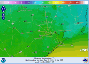
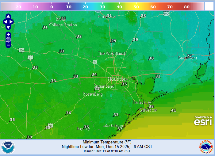
Monday Morning:
With mostly clear skies and cold air pushing into the area from the northeast the freezing line will sink southwestward toward the metro area. Winds may not completely go clam which will prevent a full temperature fall…but a light freeze in looking likely for much of the area especially north of I-10 and the normally cooler locations south of I-10. Freeze duration will be generally a small window of 2-4 hours on Monday morning. The HRRR guidance is coming in the coldest for Monday AM with 30-32 across much of the metro area.
With winds weakening into Sunday night/Monday morning wind chill values will range from the mid 20’s to near 30 across much of the area or about 5 degrees colder than the actual air temperatures.
This will be a one and done freeze threat with winds turning to the south on Tuesday and a big warm up into much of the mid to late part of next week with highs pushing back well into the 70’s and possibly near 80 and lows creeping back into the 60’s. Well above normal temperatures look likely into much of Christmas week.
Forecasted Lows Monday AM: