- Tornadoes impacted northwest Harris County Monday
- Cool and dry Thanksgiving
- Wet weather returns this weekend
Tornadoes:
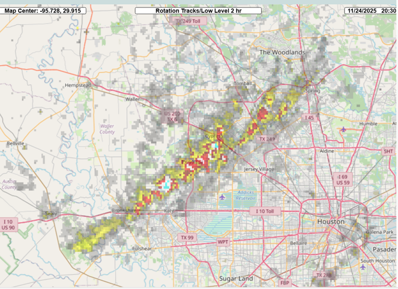
A cluster of supercell thunderstorms moved across the area late Monday morning into the early afternoon hours resulting it what will likely be at least a couple of tornado tracks. The first strong rotation and couplet was noted over northeast Austin County and moved into western Waller County. A second storm would develop north of Katy and move northeast with increasing rotation across western Harris County…damage was noted in Towne Lake with more significant structural damage in Riata Ranch on the east side of Barker Cypress south of US 290. As this storm continued northeast either the same or a secondary circulation resulted in another area of damage from east of SH 249/Louetta across Klein and Champions Forest toward FM 2920. NWS survey teams will conduct surveys of the damage today to determine the path and intensity.
Thanksgiving Day:
The severe weather threat has ended over the area with a weak frontal boundary sagging toward the coast. A secondary front will cross the area tonight ushering in a much cooler and drier air mass for Wednesday and Thursday. This will result in mostly sunny skies and lows in the 40’s and 50’s and highs in the mid to upper 60’s on Thanksgiving.
Weekend:
The next storm system in this active weather pattern will begin to approach the area on Friday with onshore winds returning moisture to the area. Think rain chances will hold off on Friday for much of the area although could see some showers late out across central TX and the Brazos Valley (yes that includes Austin on Friday evening for the big football game). Better rain chances look to develop into Saturday and linger into Sunday as the slow moving system out west pushes into the state. Don’t want to get too wrapped up on rainfall totals at this point as the trend of late has been for decreasing totals as the event draws near and we are 4 days out. Additionally, there is some difference in guidance on just how wet and when the highest rain chances may occur. At this time there does not appear to be any significant severe weather threat this weekend. Colder air may eventually work into the region late in the weekend or early next week, but this is also uncertain.
Radar Indicated Rotation Tracks for the Monday Tornadoes:

