- A strong cold front will move through the area Saturday night
- Coldest air of the season will arrive into early next week
- Strong winds and low humidity will bring near critical fire weather concerns Sunday.
A little bit of everything for everybody with this forecast…for the heat lovers today and tomorrow will feature near record highs ahead of a strong cold front that will arrive on Saturday night…unfortunately no rainfall is expected with this front which will set the stage for a period of near critical fire weather conditions Sunday and Monday.
Deep upper level trough will send the season’s first strong cold front across the area late Saturday night. You will notice and feel this frontal passage with strong cold air advection onsetting early Sunday and under full sunny skies temperatures holding mostly in the 60’s with gusty north winds of 20-35mph. Will likely see winds approach gale force over the coastal waters on Sunday as the colder air transports across the warm local waters. 1040mb high pressure cell builds southward into OK and N TX Sunday night and this will result in likely the coldest morning so far this season with widespread 30’s north of I-10 and 40’s down toward the coast. Temperatures on Monday will struggle to reach 60 for many locations with continued cold air drainage from the northeast. Tuesday morning will feature the coldest morning with light winds and clear skies….temperatures will quickly fall with many areas bottoming out in the 30’s on Tuesday morning. Will likely need to at least take a look at the potential for a light freeze Tuesday AM for some of the northern and eastern areas…bit will see how cold the higher resolution guidance comes in over the weekend.
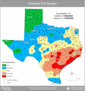
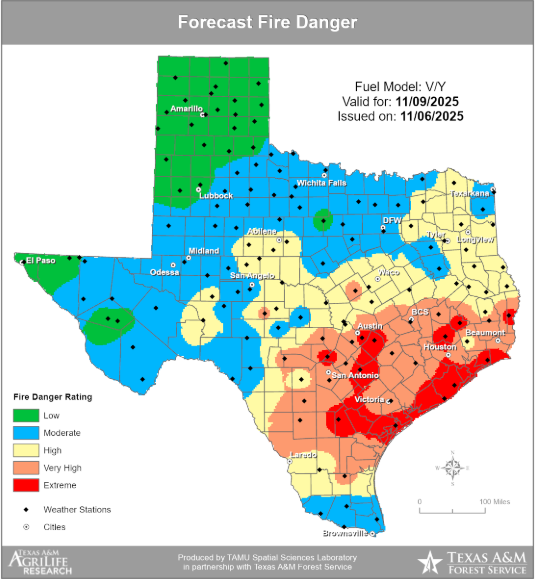
Fire Weather:
Strong cold front will cross the area before sunrise on Sunday with onset of cold air advection, gusty winds, and falling humidity values. While late October rainfall did help some, conditions have been dry and warm since then and there has been only modest recovery of fine fuel moisture much of which will be quickly dried with gusty winds and low humidity values. The area will likely be close to Red Flag Warning conditions on Sunday and TFS is indicating a very high to extreme risk of fire danger across all of the region. Strong winds of 20-35mph will result in aggressive fire growth and behavior and fast forward burn rates. Low humidity values will continue into Monday although winds will be reduced and temperatures cooler, but dry fuels will support fire growth against fairly favorable weather conditions.
Marine:
Very strong winds on Sunday into Monday will result in hazardous marine conditions and likely below normal tides by late Sunday into Monday. Tides may reach 1-2 ft below normal by Monday increasing he potential for vessel groundings.