- A strong cold front will move across southeast Texas this afternoon and evening.
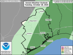
- There is a marginal risk (level 1out of 5) of severe storms developing along the front from mid-afternoon through early evening.
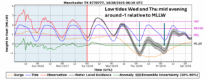
- Windy conditions and low tide levels will develop behind the front Tonight and Wednesday.
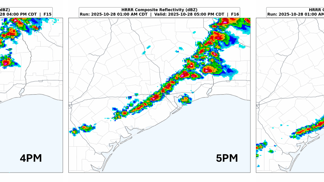
A mid and upper-level trough will move eastward across the southern Plains today. In association with this trough, a cold front will advance southeastward across Texas and reach southeast Texas this afternoon. The front should reach Conroe around 4 PM, Houston around 5 PM, and the immediate coast around 7 PM. Moisture levels will increase today ahead of the front and this moist airmass will combine with near record high temperatures (records today: 90 at HOU and 89 at IAH) to produce an unstable airmass by early afternoon.
Thunderstorms:
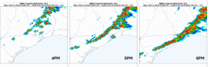
Scattered storms are expected to develop near the front as it enters southeast Texas during the early afternoon hours, a broken line of storms will form as it advances further southeast toward Houston, with a more solid line of storms as the front nears the coast and pushes offshore.
High-resolution model forecast of radar reflectivity:
The Storm Prediction Center has placed portions of southeast Texas in a Marginal Risk of severe thunderstorms. The main window for the strong to severe storms is from 3 PM to 8 PM. The main threats are large hail and strong wind gusts – but can’t rule out an isolated tornado as well.
Rainfall:
Storms are expected to progress to the southeast with the front with a quarter to a half inch of rain expected with the broken line of storms this afternoon and early evening. Locally, we could see an inch to an inch and a half of rain with the stronger storms.
Winds:
Behind the cold front tonight, the surface pressure gradient will tighten with sustained winds of 20 to 25 mph and gusts 35 to 40 mph for inland areas. Near the bay shorelines and the coastline sustained winds of 25 to 30 mph and gusts 40 to 45 mph. Strong northerly winds continue through Wednesday afternoon. A wind advisory will be required tonight for at least coastal areas.
Over the Galveston Bay and across the offshore waters a Gale warning is in effect for tonight and into Wednesday. Expecting northwest winds of 25 to 35 knots and gusts around 40 kts.
Tides:
These strong northwest winds will produce below normal tide levels tonight through Thursday. There are two periods of concern around two low tide times, especially for northern portions of Galveston Bay and the Houston Ship Channel. Those low tides occur Wednesday and Thursday evening. Around those low tides water levels could be 1 to 1.5 feet below MLLW. The low tide level on Wednesday evening will likely be a little lower than Thursday evening’s low tide. A low water advisory may be issued before the Wednesday evening low tide.
Minimum Temperatures:
Coldest temperatures of the season will occur behind this first strong Fall front. Low temperatures in the 50’s on Wednesday morning with gusty north winds and then colder into the 40’s for most location on Thursday and Friday mornings.
Halloween:
A very nice evening is shaping up for trick or treating. Expecting light winds, mostly clear skies and temperatures in the 60s during the early evening hours.
