- Heavy rainfall possible Friday night-Saturday night
- Isolated strong to severe thunderstorms on Saturday
- Some street flooding will be possible
A strong storm system currently located over southern NV will move eastward into TX over the next 24 hours and across the state this weekend Water Vapor Satellite Loop for United States | Tropical Tidbits . Moisture is starting to return off the western Gulf and this will increase today and may even get a few isolated showers west of I-45 by late this afternoon. Better influx of moisture arrives on Friday with scattered showers and thunderstorms over the area moving south to north. As lift increases into Friday night and Saturday showers and thunderstorms will become more numerous with the potential for a complex of storms to form over west TX Friday evening and progress toward the area by sunrise Saturday. This would likely be the first round of more sustained heavy rainfall. This initial line will move toward the coast, but the upper low and actual weak front linger back to the west and allow the opportunity for additional thunderstorms and rainfall into Saturday evening.
Severe Weather:
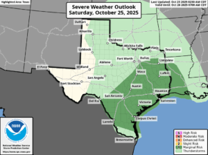
A few of the thunderstorms on Saturday could become strong to severe with damaging winds and hail being the main threats although this threat does not appear to be widespread at the moment and is secondary to the heavy rainfall. The Storm Prediction Center has place nearly all of the area under a “marginal” or level 1 out of 5 severe threat for Saturday.
Rainfall Amounts:
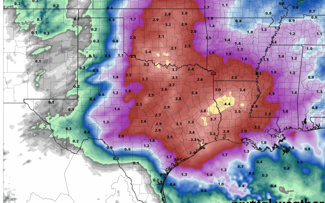
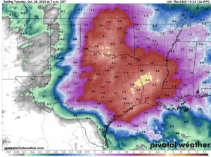
There has not been any significant adjustments in rainfall amounts over the last 24 hours with widespread totals of 2-4 inches and isolated amounts of 5-6 inches. We are starting to come into range of our shorter term guidance and will see if they offer any different suggests on rainfall amounts compared to the global models. Given the dry ground conditions flash flood guidance is high over the area and much of this rainfall will be able to be handled…in fact it is much needed…as long as it does not fall all at once. However, given the expected moisture in place along with the potential for cell training (storms moving over the same areas repeatedly) there is a risk of high short term rainfall totals that may result in street flooding and this would be especially true in any areas of poor drainage. The Weather Prediction Center has placed the area under a “slight” risk or level 2 out of 4 for flash flooding on Saturday. At this time, even going with the higher isolated totals bayous and creeks, while experiencing rises, are not expected to see any significant flooding.
Tides:
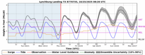
Lastly, strong southerly winds will develop ahead of this storm system and result in elevated tides Friday afternoon into Saturday night. Forecasted tides reach 3.5-4.0 ft above MLLW (barnacle level) into Saturday and with building seas some minor coastal flooding will be possible at times of high tides.
