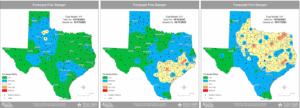
- Elevated fire weather conditions on Sunday
- Red Flag Warnings may be required for some portions of the area
A cool front currently moving into Texas will cross the region tonight with a slight chance (30-40%) of showers and thunderstorms. This will be the best chance of rain the region has seen in weeks, but actual amounts look to remain on the low side (generally less than .50 of an inch) for most areas. Can’t rule out an isolated strong storm well north of the metro area later this afternoon as heating builds some instability.
Fire Weather:
Post frontal air mass will become significantly drier with afternoon humidity values on Sunday falling into the 20-40% range over the region and north winds of 10-25mph. These weather conditions overtop of increasingly critically dry fuel loads will result in elevated to near critical fire conditions on Sunday. With fine fuels (grasses) and ladder fuels (shrubs and small trees) showing significant drought stress and dryness the ignition and rapid spread of wildland fire is becoming more likely. Additionally, fires will become more resistant to control especially with the gusty winds.
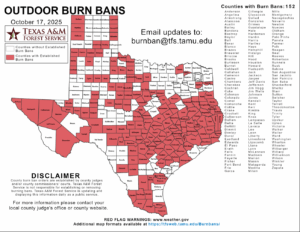
Burn bans are in effect for many counties in the region and extreme caution should be used with any items that could spark wildland fire.