- High to extreme fire danger today and Friday
- Minor coastal flooding possible through the weekend
Weak boundary has pushed southward over the Gulf waters this morning with a secondary push of much drier air heading in this direction from the northeast. This dry air mass will reach the area late this afternoon and evening and envelop the entire region on Friday. While cooler overnight low temperatures will be common (low to mid 60’s) afternoon high temperatures will continue to warm into the low 90’s but with a significant drop in humidity values.
Fire Weather:
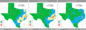
A bit more concern with this round of dry air than the last. Winds will be gusty on Friday upwards of 15-20mph during the afternoon hours with humidity values tanking into the 20-30% range over much of the area. Fine fuels have continued to dry with no widespread wetting rainfall with 10-hr fuel moisture falling to critically low values Friday and Saturday. Even 100-hr fuel moisture degrades into the 11-25 percentile for much of the region Friday into this weekend. With increased winds, low afternoon humidity values, and continued dry grasses the threat for wildland fire starts and spread is increasing. Texas Forest Service outlook has added much of the area into a high risk for fire this afternoon into Friday with portions of San Jacinto, Montgomery, northern Harris, and northern Liberty counties in a very high risk for Friday afternoon. Winds will relax some on Saturday which may help mitigate concerns some, but look to increase again on Sunday as high pressure begins to shift eastward however there is virtually no recovery in fine fuel moisture into the weekend as noted on the 10-hr and 100-hr fuel moisture plots below.

Several counties have implemented outdoor burn bans and caution should be used through the weekend to mitigate any fire starts and refrain from any activities that could start wildland fires.
Tides:
Building high pressure from the northeast will help to increase the pressure gradient over the northern Gulf Friday into the weekend with a corresponding increase in swells and water level rise along the coast. Tides are already elevated in the current “king tide” lunar cycle of fall and this will continue into next week. Tidal guidance continues to forecast values approaching 3.5-4.0 ft above MLLW (barnacle) level this weekend. These levels typically result in minor coastal flooding at the typical vulnerable areas along Gulf facing beaches and inland bays (Bolivar near Rollover Pass, west end of Galveston Island, Surfside, Toddville Rd north of Seabrook, and the Lynchburg Ferry area). With an elevated swell off the Gulf water levels may reach near the base of dunes and into beach access points at times of high tide over the weekend as well as flooding of low lying roads near the coast.

