- Surface trough/broad low pressure has developed south of the Louisiana coast.
- No significant tropical development of this system is expected as it drifts northwest.
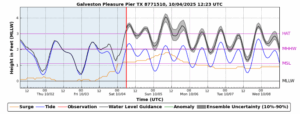
- Elevated seas and tides due to a strong pressure gradient over the north Gulf through early next week.
- Slight increase in coastal rain chances into early next week.

A surface trough/broad area of surface low pressure located south of the south-central Louisiana coast this morning is drifting toward the WNW IR Satellite Loop for Gulf of Mexico | Tropical Tidbits . Shower activity has increased and become more concentrated along the eastern flank of this feature off the southeast Louisiana coast extending southeast of the north-central Gulf. However, strong upper level westerly winds and a dry air mass located over TX is preventing thunderstorms from deepening and developing this feature and there is little to no guidance support for any sort of tropical development. The NHC gives this feature a 0% chance of any development. This feature will drift toward the WNW then NW over the next few days moving ashore over SE TX or near the LA/TX border. The majority of the associated weather activity with this feature will be located on the east side of the trough axis and generally east of SE TX across Louisiana.
Seas/Tides:
Long fetch easterly winds of 25-35mph from the western Atlantic across FL and across the entire northern Gulf will continue into early next week with strong high pressure located over the eastern US. Gulf seas will build into the 6-10 foot range through Monday and the combination of easterly wind flow, elevated Gulf seas, and high October tides will potentially result in minor coastal flooding at times of high tide this weekend into Monday. Greatest potential for any minor coastal flooding will be along the Gulf facing beaches where wave run-up will push water levels up the beaches. Highest levels approach 3.5-4.0 ft above MLLW (barnacle level) tonight into Sunday before falling back into early next week. Minor coastal flooding of low lying roadways and beach access points will be possible at high tide through Sunday.
Rainfall:
While moisture will increase, especially along the coast, the dry air wrapping southward over TX into the western flank of the broad circulation along with strong upper level westerly winds will keep the bulk of badly needed rainfall to the east of our area. Enough moisture may creep into the coastal counties for fast moving showers off the Gulf through the weekend and then expand slightly further inland Monday and Tuesday, but forecasted rainfall amounts are generally less than .50 of an inch along the coast and less than .25 of an inch toward I-10.

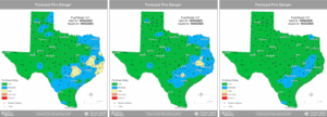
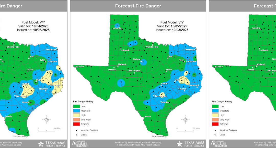
Fire Weather:
Increasing rapid onset drought conditions are in progress over much of the area with continue high temperatures, lack of widespread rainfall, and low humidity values. This is resulting in drying of fine fuels (grasses) and an increased fire danger. Recently, light winds have kept fire starts to a minimum and spread rates slow, but increased winds overlapping with still dry afternoon humidity values and poor vegetation health north of I-10 will support an enhanced fire threat through the weekend, and caution should be used with any practices that could start wildland fire.