- Tropical development remains possible over the northern Gulf later this week
- Regardless of development, heavy rains will spread westward along the US Gulf coast
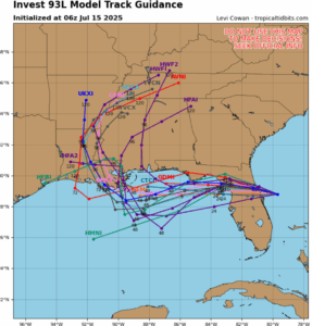
93L is currently located just off the FL space coast this morning between Daytona and Melbourne IR Satellite Loop for Invest 93L | Tropical Tidbits . Radar and surface observations show a decently defined low to mid level circulation is in place with this feature with a slow westward movement toward the FL east coast. Guidance brings this system inland across the eastern portions of FL today and then west toward the FL west coast on Wednesday before exiting into the eastern Gulf late Wednesday.
Once in the eastern Gulf, conditions appear favorable for some slow development of this system as it moves westward and then west-northwest in the general direction of the Louisiana coast. However some northeasterly shear and possible dry air may keep much of the thunderstorm activity located to the south and southwest of any developing surface center. The ICON guidance which has been by far the most aggressive model has backed down some overnight with its stronger solution in favor of a weaker idea and it in better agreement with the other guidance members and their respective ensemble suites. With that said, a tropical depression or tropical storm is possible with the National Hurricane Center currently indicating a 40% chance of development through the end of the week.
A large plume of tropical moisture associated with this system will move westward along the US Gulf coast mid to late week with the more concentrated areas of heavy rainfall more likely near where any surface center moves inland…this is currently most likely across Louisiana at this time. Some of this moisture could spread into the eastern portions of SE TX (east of I-45) by Saturday with increased rain chances, but this will depend on where any system tracks and how consolidated activity becomes around a surface center.
Monitor forecasts daily for any changes