- Heavy rainfall event underway over the region
- Numerous clusters of thunderstorms producing heavy rainfall developing along and west of I-45.
- Flash Flood Watch has been expanded to all counties.
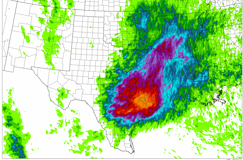
Increasing lift spreading across a very moist air mass has resulted in the rapid development of numerous clusters of showers and thunderstorms. Heavy thunderstorms over southern Jackson into Matagorda Counties have anchored with repeat cell training. Radar shows hourly rainfall rates of 2.5 inches with these cells with 2-3 hour storm totals now over 7 inches in western Matagorda County. Recent development of storms over SE Harris County have shown rainfall rates of 1.20 inches in 30 minutes. 06Z HRRR seems to have somewhat of a decent handle on the current evolution of the ongoing activity, and has had a persistence aggressive signal for excessive rainfall and flash flooding over the next 6-12 hours across the region. 00Z HREF guidance also continued the trend of higher end rainfall totals expanded further south and east with time through mid morning.
Biggest concern the next 3-5 hours will be clustering, anchoring, or repeat cell training of any storms that will lead to rapid onset flash flooding as currently occurring around Matagorda Bay. Thus far minus the cluster near Matagorda Bay, cells have been moving steadily to the north ahead of a strong disturbance west of Waco TX. It is possible that cells begin to cluster and organize in the region bounded by Waller, Harris, Austin, Colorado, and Fort Bend Counties in the next few hours as suggested by some of the high resolution guidance. Eventually a line of slow moving more organized heavy rainfall will form and progress toward the coast by mid to late morning.
Instances since 1000pm last evening over central Texas and more recently around Matagorda Bay yield the potential of this air mass with confirmed hourly rainfall rates of 2-3 inches with totals exceeding 5-7 inches in a few hours. These types of rainfall rates will result in significant flash flooding.
