High temperature yesterday of 99 at IAH shattered the previous record of 92 (2005) and 98 at Hobby broke the record of 93 (1954). Record to near record highs in the mid 90’s is again possible this afternoon ahead of a cold front that will sweep across the region late tonight and early Wednesday morning. Front will reach the coast prior to sunrise on Wednesday with cold air advection in place during the day on Wednesday ushering in a much drier and cooler air mass. Temperatures Wednesday will be at least 20 degrees cooler than today with highs in the mid 70’s with a northeast wind of 10-15mph. Lows still look to fall off into the 40’s over a good bit of the area on Thursday AM with 50’s closer to the coast. With high pressure only slowly moving eastward into late week and this weekend the dry air mass will be slow to modify helping keep temperatures mild, but slowly increasing. Rain chances look to remain low into the weekend with any return moisture aimed west of our area.
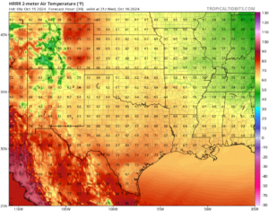
Below is the HRRR guidance temperatures for mid afternoon on Wednesday:

Fire Weather:
With the onset of a much drier air mass on Wednesday and stronger northeast winds fire weather concerns will be elevated. Current conditions (mostly with wind) keep the area below Red Flag Warning criteria, but fine fuels (grasses) have dried to the point where fire will easily start and spread. Very low humidity values will dry already dry grasses to near critical levels Wednesday and Thursday. Texas Forest Service is maintaining a high risk of wildland fire potential for much of the area on Wednesday and Thursday. While there will be little humidity recovery Wednesday PM/Thursday AM, winds will weaken over inland locations while remaining gusty along the coast into late week.

Tropics:
94L:
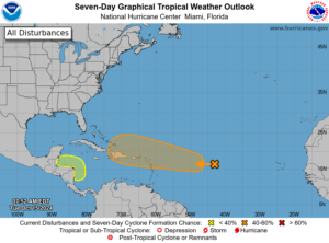
A well defined area of low pressure over the central tropical Atlantic is moving westward with limited shower and thunderstorm development. Overall environmental conditions are mostly unfavorable for development over the next 2-3 days as the system approaches the northern Leeward Islands. Conditions may become less hostile toward the end of the week as the system moves westward toward the Greater Antilles or the southern Bahamas. With strong well defined frontal systems now moving well into the Gulf of Mexico…this system looks to pose little threat to the Gulf.
Southwest Caribbean:
An area of low pressure may develop over the southwestern Caribbean Sea over the next few days. Shower and thunderstorm activity has been increasing in this area where some guidance has been hinting that an area of low pressure may attempt to develop. While the GFS model tends to have a high “false alarm” rate of development in this area there is some additional agreement from other guidance that surface low pressure may form. Any surface low that develops will likely remain close to the coast of central America before turning westward over the far southwestern Caribbean Sea late this week as a strong cold front moves into the southern Gulf of Mexico.


