
- Slow moving front will stall over the region this weekend
 \
\


There has been little change to the forecast thinking over the last 24 hours as a slow moving frontal boundary moves into the state and eventually stalls over SE TX Saturday afternoon into Sunday before washing out late Sunday. This will bring a period of active weather to the region from Saturday afternoon out north and west to much of the area Saturday night into Sunday. Strong moisture return off the Gulf is in place this morning helping to prime the area for the upcoming weather event. High resolution guidance shows the slowly sagging front arriving around College Station around midday on Saturday and possibly reaching the I-10 corridor mid to late evening. How quickly the front presses to the south will likely be driven by the amount of thunderstorm activity along the boundary…more storms could help push the boundary southward a bit faster, but looking through the high resolution guidance only shows scattered activity through much of Saturday with an increase in storm coverage into Saturday evening along and northwest of the frontal boundary.
Front will stall over the area into Sunday keeping high rain chances in place…much needed rainfall…with any lower end severe threat on Saturday likely transitioning more toward a heavy rainfall threat Saturday night into early Sunday where a period of cell training may evolve. Periods of showers and thunderstorms will continue into Sunday as the front washes out.
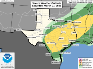
Severe:
Overall while parameters are in place for severe thunderstorms, this remains a lower end threat with a few severe thunderstorms possible (large hail and damaging winds will be the primary threats). SPC has maintained the “slight” level 2 out of 5 risk for nearly all the area on Saturday and Saturday evening. Think any late afternoon and evening severe threat will gradually transition toward more of a heavy rainfall threat overnight into Sunday morning.
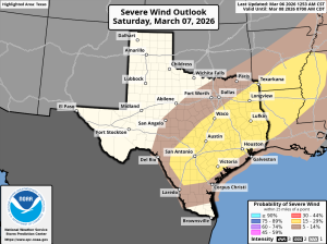
Heavy Rainfall:
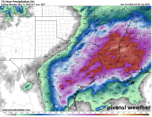
A very warm Gulf for this time of year is helping to supply an endless pump of moisture into the region and when combined with a slow moving/stalling boundary there is concern for heavy rainfall. Upper level winds may be increasing divergent aloft into Saturday night over top of the stalling surface boundary which may support slow moving and training showers and thunderstorms. The more organized storms could produce rainfall rates of 1-3 inches per hours leading to some street flooding. Activity should slowly sink toward the coast into Sunday morning. Widespread rainfall amounts of 1-3 inches will be possible with isolated higher totals upwards of 5 inches. Grounds are dry and much of the area is in significant drought so this is much needed rainfall…biggest concern is that several inches of rain could fall in a short period of time leading to rapid street/urban type flooding.
Hydro:
Area is in severe drought and much of the initial rainfall will soak into the ground. Rainfall rates will guide run-off especially into more urban areas, but currently not expecting any flooding on area creeks and bayous although some rise will be possible in the areas of more sustained rainfall. Will need to monitor the San Jacinto basin into next week with the widespread nature of the rainfall as rise are likely to be generated in the headwaters and sent downstream early next week.
