- Dangerously cold temperatures and wind chills this weekend into early next week.
- Increasing chances for freezing rain and ice accumulation for Houston metro Saturday and Sunday
- Maximum winterization preparation will be needed for this event to help mitigate infrastructure damage…completed by Friday afternoon.
Trends continue to support a large and impactful winter storm for the state and region this weekend including periods of freezing rain possibly mixed with sleet along with very cold temperatures.
Frontal Timing:
Arctic from will arrive into the area late Friday before sunset up north and Houston metro after sunset with temperatures falling from the 60’s into the 40’s behind the front. Classic arctic air masses tend to arrive in waves with each subsequent wave colder than the previous and there looks to be second and colder surge into the area during the day on Saturday. There remains uncertainty on when the freezing line will advance into the area, but likely Saturday morning north of HWY 105 and then toward the US 59/I-10 corridor some point midday into the afternoon hours before pushing toward the coast in the evening.
I want to stress that this timing of the onset of freezing temperatures is fluid and will change in the next few days.
Dangerous wind chills will be in place late Saturday into Monday ranging from the 1’s off to the north and west to the 10’s/20 toward the coast.
Temperatures:
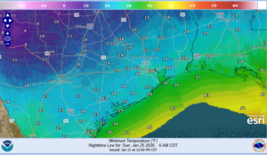
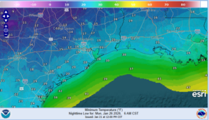
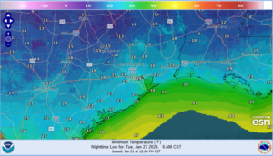
- Hard freezes for much of the area is likely Sun, Mon, and Tues mornings.
- Temperatures will likely remain below freezing on Sunday and may only briefly push above freezing on Monday.
Once the area falls below freezing Saturday afternoon and evening a prolonged period of sub-freezing temperatures in likely with durations potentially exceeding 36-44 hours over the metro area and 60-72 hours north of HWY 105.
North of HWY 105:
Sun AM: 19-21
Mon AM: 13-17
Tues AM: 15-20
North of I-10
Sun AM: 17-22
Mon AM: 17-22
Tues AM: 19-24
South of I-10:
Sun AM: 24-29
Mon AM: 18-24
Tues AM: 20-28
Precipitation:
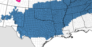
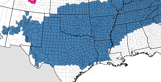
- SE TX will be on the southern edge of a potentially catastrophic and crippling ice storm across interior TX
- Ice accumulation is likely north of US 59/I-10 this weekend and even down to the coast on Sunday.
- Travel impacts are increasingly likely across much of the region.
There remains uncertainty when locations will fall below freezing on Saturday and the transition to freezing rain begins. General thinking is freezing rain/drizzle for many areas north of I-10 Saturday afternoon into the evening and then progressing southward overnight. There may be a brief lull in the rainfall on Saturday evening before a second round of steadier and heavier rainfall arrives Sunday morning into the afternoon hours. In this setup we are dealing with a moist flow aloft out of the southwest ahead of an upper level trough that will send disturbances across the area which are hard to time. There could be a period of heavy freezing rain and even some sleet mixed in on Sunday morning.
Accumulations:
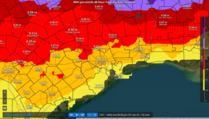
Storm event totals of .05 to .30 of an inch of ice accumulation will be possible in the Winter Storm Watch area. Highest totals will likely be north of HWY 105 (.10-.30 of an inch) with amounts of .05-.25 of an inch southward toward the I-10 corridor and generally less than .10 of an inch in the coastal areas.
Ice amounts of only .01 can result in dangerous driving conditions especially on elevated bridges/overpasses/ramps/and connectors.
.25 of an inch is generally when power outages and tree damage begins to occur.
Gusty north winds of 15-20mph through the period will add additional stress to ice coated trees and power lines and isolated power outages will be possible.
Preparations:
- Proper winterization of any exposed pipes/plumbing will be needed to prevent infrastructure damage. Sprinkler systems must be shut off and properly drained. Exterior facing wall pipes will be a risk of freezing at the forecasted temperatures.
- Pets/livestock will require proper shelter to protect from the cold temperatures and wind chills.
- Tropical plants/vegetation will require maximum freeze protection. Unprotected tropical vegetation will be killed and even protect vegetation will likely suffer heavy damage.
- Persons should limit outdoor exposure during the cold. Utilize heating sources properly to reduce the risk of fire and carbon monoxide poisoning.
All cold weather preparations should be completed by Friday afternoon prior to the arrival of the cold front.