- Dangerously cold temperatures and wind chills this weekend into early next week.
- Increasing chances for freezing rain and ice accumulation for Houston metro Saturday and Sunday
- Maximum winterization preparation will be needed for this event to help mitigate infrastructure damage…completed by Friday afternoon.
Unfortunately, the trend in the last 24 hours has been generally colder across the guidance spectrum yielding a continued decrease in the temperature forecast. Arctic front looks to arrive either late Friday afternoon or evening across the area (timing is still a bit uncertain) with falling temperatures and onset of gusty northerly winds. Freeze line likely to advance southward Friday night/Sat AM to a line from Columbus to Hempstead to Porter and then continue southward during the day reaching the I-10 corridor midday to mid afternoon and the coast by early to mid evening. How quickly the freezing line moves south will be very important on freezing rain probabilities and ice accumulations.
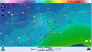
Hard freeze (24 or below) is likely for much of the area on Sun AM and even colder Mon AM with lows into the upper 10’s outside the Beltway and low to mid 20’s to the coast…and mid (possibly even low) 10’s across the Brazos valley….this will be a damaging freeze. High temperatures on Sunday will struggle to reach freezing and this may result in duration of temperatures below freezing nearing 40 hours or longer for much of the metro Houston area and up to 72 hours for areas to the north and west. High temperatures on Monday may only reach the mid to upper 30’s for a few hours.
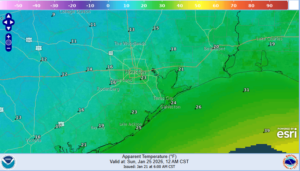
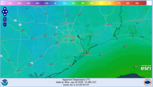
Wind chills will become dangerous with values falling into the 10’s late Saturday into much of Sun (low 20’s in the Houston metro) and then down to the low 10’s Sunday night into Monday AM (could even get 1’s in north and west areas).
Precipitation:
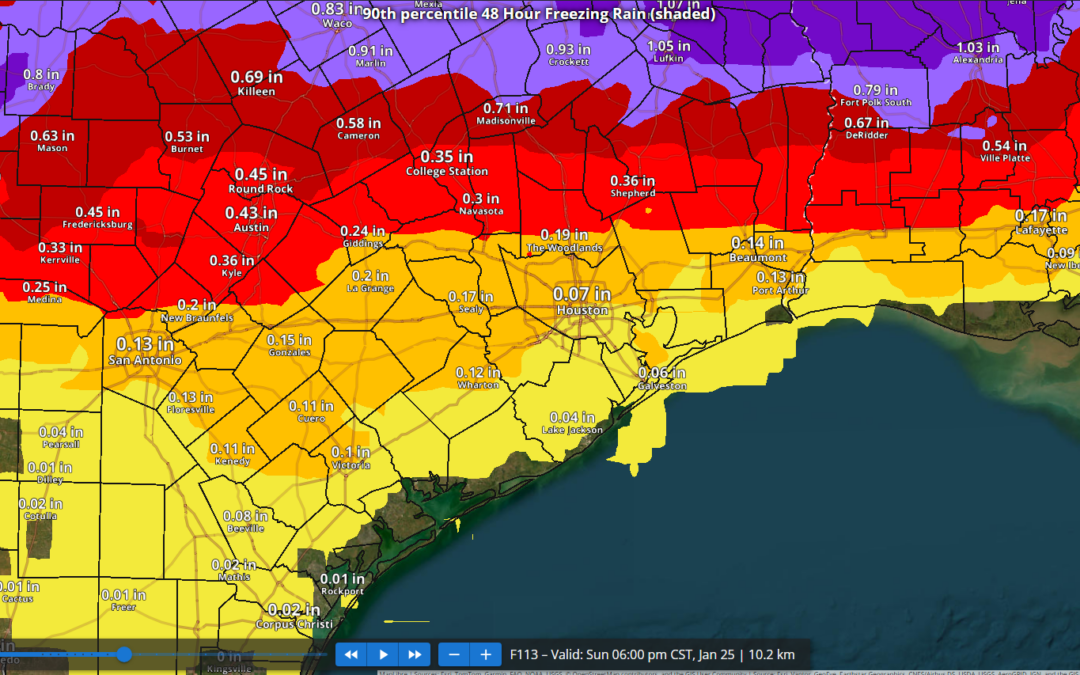
- SE TX will be on the southern edge of a potentially catastrophic and crippling ice storm across interior TX
- Chances for ice accumulation have increased across all of SE TX with potential for at least minor accumulation to the coast.
- Travel impacts are increasingly likely across much of the region.
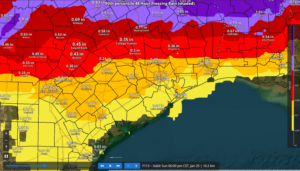
Once the arctic front is through Friday evening the freezing line will advance southward…GFS appears to be resolving the intensity of the cold air mass best and pushes the freezing line toward I-10 by midday Saturday with freezing rain developing southward during the day. There is still some uncertainty in how quickly this happens and the high resolution guidance tomorrow should help with timing onset of freezing precipitation. Given this faster onset the potential for higher ice accumulation of .05 to .20 of an inch is being brought toward the US 59 corridor with more significant accumulations of .25-.45 of an inch north of HWY 105. Ice accumulation of .20-.25 of an inch is where we begin to worry about power infrastructure damage along with vegetation impacts and areas north of HWY 105 look to reach this range. Freezing rain should gradually end around midday Sunday, but it is possible that freezing drizzle or mist lingers into Sunday afternoon given a saturated air column and very cold air which is effective a squeezing moisture out.
It should be noted that similar to rainfall events there will be pockets of higher ice accumulation and areas of lower accumulation and this is an early look at accumulations so changes up or down will be possible.
Additionally north winds of 15-20mph through the period will add additional stress to ice coated trees and power lines and isolated power outages will be possible even down to the coast.
Preparations:
- Proper winterization of any exposed pipes/plumbing will be needed to prevent infrastructure damage. Sprinkler systems must be shut off and properly drained. Exterior facing wall pipes will be a risk of freezing at the forecasted temperatures.
- Pets/livestock will require proper shelter to protect from the cold temperatures and wind chills.
- Tropical plants/vegetation will require maximum freeze protection. Unprotected tropical vegetation will be killed and even protect vegetation will likely suffer heavy damage.
- Persons should limit outdoor exposure during the cold. Utilize heating sources properly to reduce the risk of fire and carbon monoxide poisoning.
All cold weather preparations should be completed by Friday afternoon prior to the arrival of the cold front.