- Heavy rainfall and flash flooding possible tonight into Thursday mainly northwest of the Houston metro area
- Monitor heavy rainfall trends tonight into early Thursday for any shifts southward in the forecast
A complex forecast for tonight into early Thursday as a broad upper level trough resides over W TX with a very moist air mass over SE TX on the eastern side of the upper level trough. Air mass is into recovery mode after the morning complex of storms and this will continue into the early to mid evening hours with little to no rain/storms expected for the next several hours. After midnight showers and thunderstorms are expected to develop either over central Texas or across the northwest portions of SE TX. These storms may initially show slow storm motions and cell training which will greatly increase excessive rainfall potential and flash flooding. How these storms initially evolve and at what point they begin to push southeastward is uncertain. High resolution guidance today continues to show a persistent signal for storms to develop over the Brazos valley bounded by College Station, Columbus, Conroe, and Hempstead and slowly push southward before gaining a bit more forward speed/progression after daybreak on Thursday. However it is possible that storms could develop either further south or north in this setup…a trend that will need to be watched closely overnight. Recent 18Z HRRR is much more aggressive with the storms firing a bit further southward tonight into the NW side of the metro area…again a trend that will need to be watched closely.
Factors are certainly in place for heavy to excessive rainfall rates including tropical moisture, weak low level inflow off the western Gulf, slightly splitting winds aloft, and generally warm rainfall processes that maximize rainfall efficiency. This setup has some similarities to events in July 2012 and early August 2017 but of which produced slow southward moving heavy rainfall and flooding on the eastern/southern flank of a trough over central Texas. This is the type of situation where things can go “bad” fast as rainfall rates can quickly pile up in a short period of time. I am always a bit nervous with expected heavy rainfall to the northwest as these types of systems like to build southward into the Gulf inflow and we will need to watch for that late tonight into Thursday morning.
Rainfall Amounts:
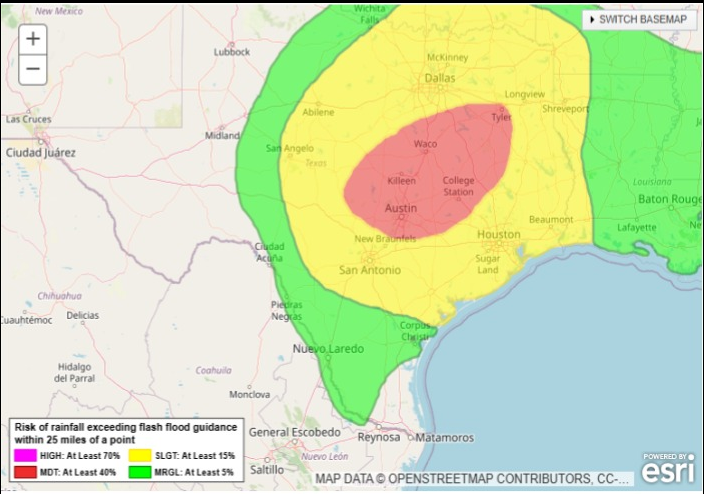
Rainfall amounts of 2-5 inches are likely tonight into Thursday along and northwest of a line from Columbus to Hempstead to Conroe with isolated higher totals upwards of 8 inches or greater. Some of the more extreme guidance solutions today have suggested upper bound totals of 10-12 inches and this would be considered to higher end worst case scenario. Elsewhere rainfall amounts of 1-3 inches will be common with isolated higher totals. It would not take much of a shift to bring some of the higher totals into Waller, NW Harris, and southern Montgomery Counties and this will need to be watched closely as this area would be more sensitive to heavy rainfall.
Rainfall rates will be key to flash flooding potential with possible hourly rates as high as 2-4 inches per hour given the saturated air column and threat for slow moving or training storms. Street flooding would be likely with these type of rainfall rates.
Grounds are starting to saturate over the area, especially those areas that have seen rainfall amounts the last 2-3 days. Many areas saw 0.5-1.5 inches of rainfall this morning, but in some areas this is on top of previous rainfall this week. Given the increasing soil moisture, run-off will be increasing moving forward and any areas of concentrated heavier rainfall will generate large amounts of run-off and rises on creeks, bayous, and rivers. Current watersheds to at least keep an eye on with the current forecast is the West Fork of the San Jacinto River, Lake Creek, Spring Creek, Cypress Creek, Willow Creek and Little Cypress Creek.
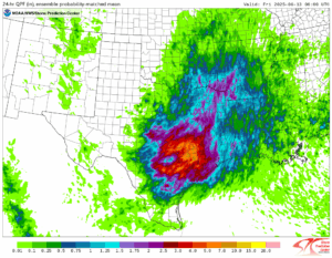
Possible rainfall next 24 hours. Isolated higher maximum totals.
