Active weather will return to the area as early as this afternoon and tonight.
A thunderstorm complex currently along the Red River will build southward through the day and approach SE TX late this afternoon and evening. Latest high resolution guidance runs show this complex holding together and pushing into the metro area overnight and off the coast early Thursday morning. There will be a threat of severe weather with this line of storms mainly in the form of damaging winds. The greatest severe threat will be north of I-10 this evening with activity weakening toward the coast into the early morning hours of Thursday.
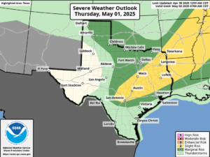
Thursday presents a somewhat interesting day for the region with expected morning storms weakening off the coast and moving eastward into LA while heating may induce additional development Thursday afternoon into the evening hours in an area from NW of Houston to Waco to west of Austin. This area is being highlighted by SPC (Storm Prediction Center) for an enhanced hail risk. These storms may eventually grow upscale into a cluster or complex and move across portions of the area Thursday evening. This is a somewhat conditional threat depending on air mass recovery behind the thunderstorms expected tonight/Thursday morning.
A weak frontal boundary approaches Friday and guidance has been hinting at a line of weather associated with this front for days now to cross the area Friday afternoon and evening. Timing of the front in the peak of heat of the day or just afternoon suggest at least some severe weather risk will be possible.
Front sinks toward the coast early Saturday and stalls with a slightly drier air mass pushing into the central and northern portions of the area early Saturday. This will be short lived as the weak boundary begins to retreat northward on Saturday along with deeper Gulf moisture and at least some rain chances.
A deep layer upper level trough begins to dig into the SW US late this weekend with mid level ridging developing over southern Texas. This should bring a brief lull to the active weather with warming temperatures and lower rain chances Sun-Tues. Beyond Tuesday, this upper trough begins a slow movement eastward toward the state and parameters and starting to appear to be coming together for an extended period of active weather including both severe and flooding threats. With the upper air pattern over the US transitioning more toward a slowing/blocky pattern, this may slow the ejecting storm system mid to late next week over portions of Texas resulting in repeated rounds of weather.