Widespread rainfall…some heavy…late this week.
In a complete 180 turn from the recent weeks…widespread and significant rainfall is likely Thursday and Friday. A low latitude southern stream storm system will move from northern MX across TX late this week. The position of this system is much further south than most of the storm system over the last few months and this will allow much better dynamics aloft and lift across the parched locations of south-central and southeast Texas. There are still some model differences in the timing, amounts, and location of the highest totals, but blended solutions bring significant rains to a good portion of the area Thursday and Friday.
With approach of the upper level system late Thursday, surface low pressure is likely to form somewhere over SC TX or the coastal bend and move across SE TX late Thursday into Friday and this feature will likely force widespread areas of deep convection. Air mass becomes increasingly saturated on Thursday with moisture values off the warm Gulf pushing near the 90th percentile for late March. A weak surface boundary may also approach from the northeast and help to act as a focus for more sustained convection. Recent trends have been to highlight the area from the coastal bend into southeast Texas for a corridor of heavier rainfall and shift to the southeast over the last 24-36 hours and a standard trend in guidance with TX rainfall events that tend to initially focus too far inland. While rain is much needed over the area, there is the potential for too much of a goo thing and too fast with parameters in place to produce heavy to excessive rainfall rates in the stronger storms. The best potential for this will be late Thursday into Friday as the surface low moves over the area and there could be a period of repeat cell training.
Rainfall Amounts:
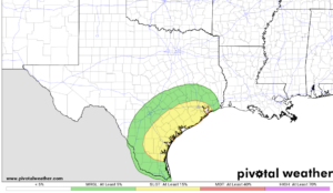
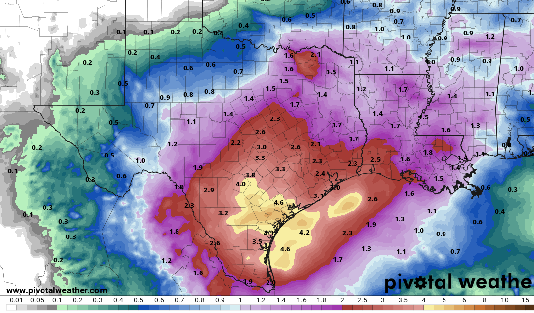
Widespread rainfall totals of 2-3 inches are becoming likely over the region with isolated totals of 4-5 inches. 10% probability totals are greater than 6 inches in areas southwest of Houston including around a 10% chance of greater than 8 inches over Matagorda County back west into Jackson County. Dry grounds will initially absorb much of this rainfall, but repeated rounds of storms and potential for 2.0+ inch per hour rainfall rates does pose some flash flood risk. WPC has placed much of the area south of I-10 in a slight risk (2 out of 4) for flash flooding Thursday and Friday. It needs to be noted that guidance has been trending upward with rainfall totals and this will need to be monitored over the next few days.
Storm system and heavy rains will progress eastward by late Friday into early Saturday leaving the region with decreasing rain chances.