Significant cold air outbreak mid next week.
Surface trough and coastal low forming off the lower Texas coast will move northeast allowing a warm front to move into the area late tonight into Saturday. A few scattered showers may develop this afternoon ahead of the warm front into tonight. A cold front will then move across the area quickly Saturday afternoon and evening. While decent moisture does return to the area tonight and Saturday it appears the main lift will be well to the northeast of our local area and that a thin line of showers and thunderstorms will form as the front crosses the region. Highest chances for thunderstorms will be northeast of the Houston metro area and can’t totally rule out an isolated severe storm…but this threat is much higher to the east of our local area.
Northerly winds will drive temperatures into the 30’s for many areas by Sunday morning and possible for freezing conditions (light freeze) for areas north of I-10 on Monday morning.
Next system approaches the area Tuesday into Wednesday with another round of showers followed by an intrusion of cold arctic air.
Mid Next Week:
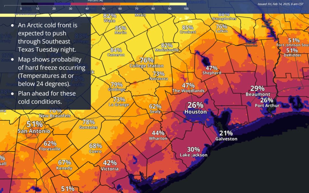
Upper air pattern will buckle allowing a large sprawling 1055mb+ arctic high pressure system to descend southward down the plains and deep into TX. Temperatures of -35F to -45F along the Canadian border early next week plunge southward down the plains with an arctic front plowing across Texas Tuesday into Wednesday. This looks to be a classic southern plains cold air outbreak with arctic air mass plunging southward along the higher terrain of the Rockies and mountains of northeast MX. While the overall pattern supports a significant intrusion of cold air into the area mid next week…there remains uncertainty on how intensity the cold air mass will be and how low temperatures will fall. Current indications suggest a hard freeze over much of the area by next Thursday morning (2/20) with freezing temperatures down to the coast. When combined with strong northerly winds wind chills will fall toward dangerously low levels in the 1’s and 10’s.
If this forecast continues to hold through the weekend cold weather precautions will be needed for the middle of next week.
As for any winter precipitation…it appears that rainfall on Tuesday and Wednesday will end prior to any freezing/sub-freezing conditions although this is still several days out, and only slight timing differences could allow precipitation to linger longer in the increasingly cold air mass. For now, do not expect any freezing/frozen precipitation in our local area.
