Rain chances increase this evening into Tuesday and Wednesday.
After what has been a week or longer of record high temperatures a weak cool front has moved into the area overnight. The boundary has reached the coast and pushed offshore with slightly drier and cooler air moving southward into the region. Guidance suggests this boundary will stall and begin to move back northward as a warm front later today and this evening. This will potentially create a significant temperature gradient over the area with 60’s/70’s near the coast possibly up to I-10 and 40’s and 50’s for areas north and west of the metro area.
With southwest flow aloft upper air disturbances will move across the area starting later today and lasting into Wednesday. A slow moving warm front will combine with increasing moisture to produce a chance of showers increasing from the coast northward later this evening into Tuesday. Best rain chances will come Tuesday morning into midday along and north of I-10 where the best lift north of the warm front will be found. Guidance may be a bit aggressive in lifting the warm front northward so there is potential for temperatures to be several degrees off of forecasted values…especially in the I-10 to HWY 105 corridor.
Will see a brief break in rainfall late Tuesday into Tuesday evening before another round approaches from the west early Wednesday. This disturbance will be stronger and push the frontal boundary lingering over the area southward and well out into the Gulf with a much cooler air mass filtering into the region Thursday and Friday. Lows Friday morning could fall into the 30’s over much of the area.
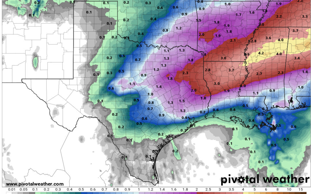
Rainfall totals over the next 48 hours will average 1-2 inches north of I-10 with significantly lower amounts toward the coast of .25 to .50 of an inch. Some locations near the coast may see less than .10 of an inch. Sea fog which has plagued the coastal areas for the last week will briefly abate this morning with northeast winds only to potentially return tonight into early Wednesday. A push of stronger northerly flow and cooler/drier air late Wednesday will end the sea fog threat into this weekend.
