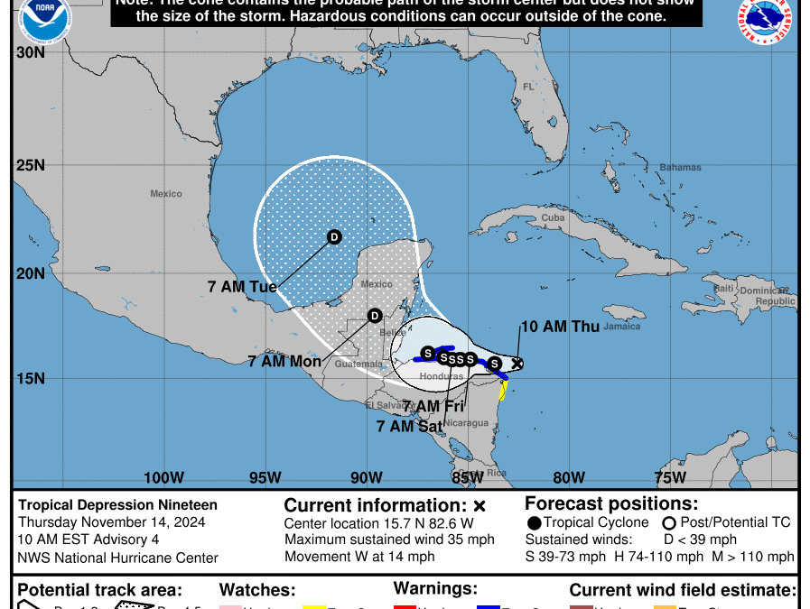
Tropical depression forms over the western Caribbean Sea.
Discussion:
Visible satellite images show a developing tropical system off the northeast tip of Honduras with a clearly defined low level circulation and large bursts of deep convection to the south and west of the center along with banding features to the north True Color Satellite Loop for Western Atlantic | Tropical Tidbits . Thee appears to be a slight amount of dry air limiting thunderstorm activity on the northeast side of the circulation currently. An USAF plan will investigate the system to determine if a tropical storm has formed.
Track:
There has been a significant shift in the forecast track guidance as well as the NHC track over the last 24 hours. The TD formed a bit further south than expected and has been moving slightly south of due west along the southern edge of a mid level ridge of high pressure over FL. This will result in the system coming close to the northern coast of Honduras through the next 2-3 days and it is possible that the system moves inland over northern Honduras during this time period. This greatly limits the intensity of the system due to the land interaction. Ridging will break down into early next week ahead of an approach deep layer trough over the central plains which will turn TD 19 northwest and north-northwest into the southern Gulf of Mexico. Given the now expected large amounts of land interaction and a much weaker system overall through the period the track reasoning is likely to be controlled more by the low level flow.
It is possible that the system moves inland over portions of central America or the Yucatan and dissipates.
Intensity:
While the depression is in favorable conditions, the interaction with Honduras will likely cap/limit the upper end potential with the system over the next 4-5 days. All intensity guidance has significantly reduced the expected intensity range for TD 19 and it is possible that the system will dissipate over portions of central America. Should it reach the southern Gulf of Mexico and powerful frontal system moving off the Texas coast early next week will produce strong deep layer shear over the system likely resulting in additional weakening over the Gulf of Mexico.
With a strong deep layer trough and front moving into the southern plains early next week…this system poses no threat to the Texas coast.


