A cold front currently extending from west of Fort Worth to near Del Rio will sweep across the state today with a drier and cooler air mass moving into the region this afternoon and evening. Not expecting any rainfall with this front with moisture levels fairly meager and best dynamics well north of the region. Cooler and drier air mass will result in temperatures falling into the 40’s by Friday morning over much for the area with highs on Thursday in the lower 70’s.
Cold surface high pressure begins to move eastward this weekend with onshore flow returning along with moisture and humidity and warming temperatures. May see just enough moisture by Sunday for a few scattered showers in the southeasterly flow.
A much stronger trough and potentially significant cold front looks to enter the state around Tuesday of next week. A robust trough looks to drive a strong cold front across the state Tuesday afternoon with significantly colder air moving into the area on Wednesday. Will see if the frontal timing and intensity of the cold air holds over the next few days…but an early look at temperatures suggest highs in the 50’s and 60’s and lows in the 30’s and 40’s for mid to late next week.
A combination of northeasterly winds behind the cold front later today and high lunar tides will result in the potential for coastal flooding along the upper Texas coast late this week into this weekend. Current total water levels look to peak around 4.0 ft MLLW at times of high tide which is near the threshold for local coastal flooding impacts especially at the normally vulnerable locations on Bolivar and in Brazoria County.
Tropics:
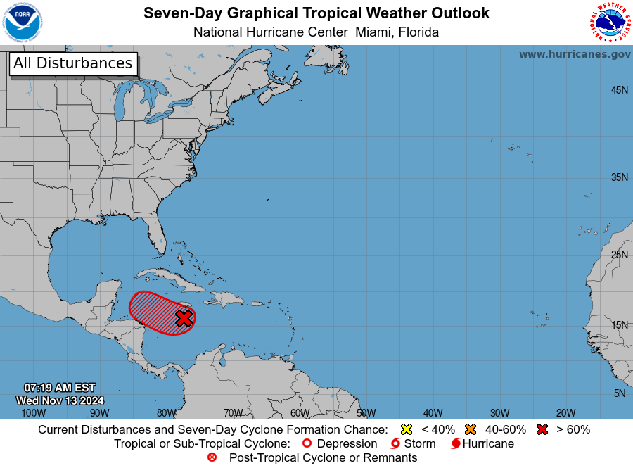
A broad area of low pressure over the west-central Caribbean Sea will move slowly westward and has a high (90%) chance of development into a tropical system. Satellite images this morning indicate the system is slowly becoming better organized and a tropical depression is likely to form later today or tomorrow. The system will drift westward toward the northern coast of Honduras over the next few days and then turn toward the WNW and NW by this weekend with a potential threat to the eastern Yucatan. There could be slow and erratic motion given generally weak steering in this area. The intensity forecast becomes problematic given favorable conditions for intensification over very warm waters under ideal upper level conditions. Several models show significant intensification of this system as long as it remains offshore of central America. It is certainly possible that a significant hurricane event occurs over the western Caribbean Sea by this weekend. The longer term track is uncertain as the deep layer trough approaching Texas early next week will likely be the guiding factor in pulling the tropical system out of the western Caribbean into the southeastern Gulf with a turn toward the NE and ENE in the general direction of southern FL. While the overall pattern does raise a concern for a hurricane landfall in SW FL or the FL Keys…the details of the exact track will determine the ultimate final outcome along with how quickly the trough sweeps in from the northwest.
Interest in the western Caribbean Sea and southern FL should be closely monitoring this system.
JL


